Editor’s Note: This video report was produced by African Stream.
Nubians are one of the oldest peoples of the Nile Valley. They are also one of its most recently displaced. Originally from Sudan and southern Egypt, Nubians had settlements going back 7,000 years in this cradle of civilization. That is, until massive, state-driven construction projects came along, forever changing the environment—and their lives.
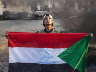
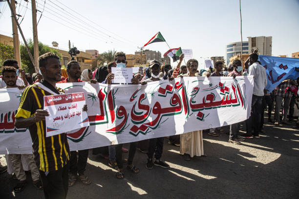
Protester holding the Sudanese flag in Khartoum after the October 25 coup / credit: Revolutionary masses of Sudan
Editor’s Note: These interviews with Khartoum-based activists that the author conducted represent part 2 of a two-part series on the Sudan coup. The first part can be read here. Certain interviewees chose to use their first name or initials because of perceived security risks.
Muzan Alneel, Marxist Political Activist and Blogger
Krisboo Diallo: What is your opinion about the recent events in Sudan… Were you surprised by the coup?
Muzan Alneel: A change that leads to further concentration of power at the hands of the military was expected. To go with a plain and simple military coup, using pickup trucks and DShKs [Degtyaryova-Shpagina Krupnokaliberny, a Soviet heavy machine gun] was just a bit too silly and weird. Nevertheless, it was not a surprise. Not to me. And as I saw, not to the Sudanese public, who on October 25 looked relieved more than anything, and many using the phrase “delayed battle” to refer to the coming post-coup struggles and fights with the military.
I was surprised by the way in which the November agreement was announced. The prime minister and the military have put so little effort in manufacturing popular support for the agreement and then took a great risk by announcing it as a pre-planned large-scale demonstration [that] was taking place. They created a space for the public to instantaneously debate the agreement, share their thoughts on it and eventually rejected with chants that spread across cities on the same day.
This tells me that Prime Minister Abdalla Hamdok read the output of the last two years very wrong. It seems he thought his unpopular policies that people often warned him [against] implementing were accepted due to a personal carte blanche he has from the Sudanese people and that it will work for the agreement, too. And that is not true. In reality, the public had clear enemies (the previous regime), but was not clear in their definition of allies, due to lack of clarity in the definition of demands and policies necessary to deliver them. This stance against the previous regime was translated [as] support for the Forces for Freedom and Change (FFC, civilian group). Then and as the FFC started compromising more than the public can justify support, moved only to SPA (Sudanese Professionals Association) with clear rejection of the FFC, and in the same manner from the SPA to the civilian cabinet, and finally to just Hamdok. A better reading of the situation would have told him that his action will lead to a divorce between street action and the classic elite and bourgeois political club. Fortunately for Sudan, he miscalculated, leading to a level of radicalization in the streets that would have taken great effort and organizing to reach, if not for that.
KD: Is the civilian component an expression of the aspirations of the revolutionary masses?
MA: No, it isn’t. The policy decisions taken by the partnership government over the past two years and the efforts that the civilian component spent on passing these policies (e.g., economic liberalization policies [neoliberal policies]) are counter-revolutionary policies that, by definition, do not express the [demands] of the revolutionary masses.
The support for the cabinet was coming from the idea that there’s a common enemy, i.e., the NCP regime (National Congress Party). Even at the time when they implemented counter revolutionary policies and decisions, the majority said criticizing the cabinet will lead to strengthening the pro-NCP or pro-military arguments.
After the coup, and as a more radical position was adopted by the majority of those in the streets, the members of the civilian components—whether those not detained or those detained and later released—were still putting out their reformist statements. Even their supporters, who once justified their actions as wise, realistic and clever in handling the military, rejected them. Some of them who made the mistake of joining the demonstrations and trying to share their reformist speeches in the streets were rejected and ridiculed by the masses.
KD: The basic structure and strikes are the best way to bring down the coup?
MA: Strikes and civil disobedience (in all their possible and new forms) are the only unarmed path to bring down the coup.
The Sudanese people have watched armed resistance trying to take a shot at the NCP regime for decades with little success and extremely high risk to their communities and the overall population.
It had been our experience that armed resistance was used by the NCP to justify extreme violence and the NCP often dealt with it by creating and arming pro-government militias across ethnic lines, creating ethnic divisions and a decay in the relationship between the state and citizens that we will be dealing with for a very long time. Probably much longer than after we deal with all the militias (armed forces and RSF “Rapid Support Forces” included).
KD: What do you think about the position of regional and international powers on the current events in Sudan?
MA: International powers are following their usual path prioritizing and supporting a dictatorial form of stability over all other possible paths. It fits with their interests, so that is no surprise. Regional powers have taken a few steps back this time, it seems, in comparison with 2019. The messages from the United States asking Egypt and the Gulf states to step back might be the reason.
I believe it is also becoming clearer to the agents of international powers in Sudan that their “contacts” in the political club are no longer able to control the masses, or even reflect or predict their actual position. We can see them in Khartoum now, reaching out to create new “contacts” in spaces previously too radical for them to acknowledge, whether officially by meeting invitations or the usual tricks of closed meetings, support and “workshops.”
These actions must be watched carefully. The recent meeting invitation to resistance committees from the UN SRSG (UN Special Representative of the Secretary-General) Volker Perthes brought up a debate regarding how to deal with the international community. The UN Secretary-General [António Gutteres]’s latest statement about how the Sudanese should accept the deal pushed more people to reject the UN, or at least see it in a negative light. All committees rejected the first invitation for the first meeting. In the second meeting, some rejected [while] some joined, and asked for them to live-broadcast it and stated their rejection of the UN’s approach.
Those international mediators are a threat to the resistance committees and are working very hard to co-opt it. This, in my opinion, is the main issue we should focus on and fight in terms of international interventions. The rest—statements, sanctions, etc.—are just official blah blah blah.
KD: Does the international community have ambitions or interest with the military government?
MA: It was clear over the past two years that the international community and the International Monetary Fund (IMF) pushed for different schemes of privatization to deal with military investments. This reflected their priority to remove an armed player from the market. Other forms of army intervention in politics (e.g., oppression of the masses) are of no importance to the international community. It seems from what we saw in the past two years the international community would prefer dealing with a neoliberal civilian government, but can tolerate the military staying in the market (or even dominating it, as is the case in Egypt) for “stability.”
Maysoon Elnigoumi, Radical Writer
KD: What is your opinion about the recent events in Sudan… Were you surprised by the coup?
Maysoon Elnigoumi: I guess we have always anticipated a coup since the signing of the partnership between the military and the Forces for Freedom and Change (FFC). For the past year, we were all watching what could only be described as an escalation in the relationship between the military components in the government against their civilian partners. The language was very aggressive and provocative. On the other hand, the civilian partners kept speaking about a “harmonious relationship.” Despite this, the coup was still a surprise for me. I guess it was this desperate need to believe in our political parties and political elite, that they know what they’re doing, something like the adults in the room. But the coup has freed me from this delusion, I think.
KD: Is the civilian component an expression of the aspirations of the revolutionary masses?
ME: Right after the election of the FFC, you could see them moving away from some of the revolutionary slogans they have been repeating, and adopting the discourse of officials in the time of the Omar al-Bashir dictatorship. For example, about how subsidies benefit the rich or how the bread queues have disappeared, as well as the clouded statements concerning the “peace agreement” and “transitional justice,” which nobody still knows what they mean by it.
KD: The basic structure and strikes are the best way to bring down the coup?
ME: I think the strikes, the protests and the grassroots local movements are about reimagining the political scene Sudan inherited since colonialism and post-independence, in which a minority of tribal leaders, political elites and army generals set the political agenda of the state. This current movement is shifting from trying to exert pressure on a new kind of political agreement, in which the army is kept out of politics and the country is run by the traditional civilian political elite, because the statements by party leaders [indicate] they cannot envision a political establishment that does not include the army. You can see the statements by neighborhood committees now focusing on politics on the local grassroots level.
KD: What do you think about the position of regional and international powers on the current events in Sudan?
ME: From the very beginning, there was reluctant support [for] the revolution by certain regional powers. It was not until [they] had seen the same military leaders in power after the signing of the agreement that [they] shifted [their] position. Having General Abdel Fattah al-Burhan as head of the Sudanese Sovereignty Council and [General Mohamed Hamdan Dagalo] Himedti as deputy vice president of the council [guaranteed] continuing business as usual during the times of the ousted Bashir regime, whether continuing to providing manpower for the Yemen war, or land grabbing in Sudan, or curbing Iran’s influence in the region. The civilian component was unable—or perhaps unwilling—to change anything from the previous regime agenda.
KD: Does the international community have ambitions or interest with the military government?
ME: One of the victories touted by the civilian led government of Prime Minister Hamdok is the “return” of Sudan to the embrace of the “international community,” after 30 years of estrangement from international politics. However, it’s the clichéd narrative: Sudan frees itself from the shackles of despotism into the arms of unhinged structural adjustment programs, with plenty of sweet promises and bonuses from the international community, and becomes the new poster child for the IMF and proponents of the free market and the “smart” limited role of government and public institutions.
The international community wants a government that does not disrupt the narrative of current world affairs. However, it wants [the government] to continue in that role without the embarrassment of supporting a military government that targets peaceful civilians and commits crimes. That is why it is very active in the intermediary efforts of selling a power-sharing agreement to the world and to the Sudanese people, using the same condescending language of colonialism: That the people of Sudan should accept the current power-sharing agreement, as it is “best for them,” and marketing it as a rational choice, gaslighting the current revolution as irrational and unreasonable.
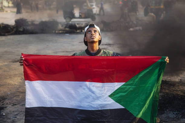
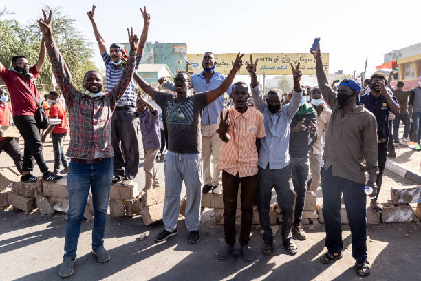
Protesters in Khartoum, Sudan, after the October 25 coup / credit: Revolutionary masses of Sudan
Nabila, Union Activist
KD: What is your opinion about the recent events in Sudan… Were you surprised by the coup?
Nabila: These last events were expected as there were indicators that pointed that there was an imminent coup, just by analyzing the escalating events. I was not surprised, but I had my doubts at the beginning that the military would actually execute a coup. But the bickering and the confrontation within the Sudanese Sovereignty Council and between the ministers confirmed my doubts.
KD: The basic structure and strikes are the best way to bring down the coup?
Nabila: I don’t expect that the demonstrations, nor the grassroots movements nor civilian disobedience, may defeat the coup. On the contrary, after the previous strike it seemed the authorities worked hard to dismantle the unions. But because the grassroots movement is widening its base and more people are joining, it might lead to gradually limiting the regime’s powers and influence. Perhaps this grassroots movement may reach the military institution itself and the lower ranks might self organize. The combination of civil disobedience, grassroots organizing and demonstrations may change the nature of the alternative oppressive regime, a regime which allows for a wider margin of freedoms that may allow us to organize, perhaps one that maintains one’s right to life. I am not concerned anymore with defeating the coup, but rather with how far this grassroots movement can go and what it can achieve. I believe instability of civilian rule since independence has not allowed for the building of a strong grassroots movement (meaning unions). Then it was followed by the 30 years of [Islamist] Ingaz rule, which completely dismantled the unionist movement. However, now the concept of grassroots organization has expanded to include neighborhood resistance committees and the talk for the need of local councils and local representation. Perhaps if this grassroots movement is able to maintain a balance of powers, which includes the military on one hand, and the political parties and the powerful elite on the other, perhaps we may reach some form of democratic rule, in which all parties are in a win-win situation. However, it’s hard to say what the military really wants or to what extent this balance of powers may compromise or handle. I guess this is a question we all need to think about.
KD: What do you think about the position of regional and international powers on the current events in Sudan?
Nabila: The regional powers are only concerned with serving their own agenda that benefits them. Nothing new here. But what should change is how we could regain sovereignty and limit their influence.
KD: Does the international community have ambitions or interest with the military government?
Nabila: The international community won’t have a problem with supporting any regime as long as it fulfills their wishes. Had this regime been able to gain a wider popular base, it would have been supported by the international community. I mean, why are we even presuming this? Look at [President Abdel Fattah al-] Sisi in Egypt. He has the support of the international community.
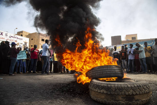
Protesters in Khartoum, Sudan, after the October 25 coup / credit: Revolutionary masses of Sudan
Tametti, Member of a Neighborhood Resistance Committee
KD: What is your opinion about the recent events in Sudan… Were you surprised by the coup?
Tametti: All the crimes that resulted from the coup, the murders, the detentions, the torture, the stifling of freedoms—not only in Khartoum, but also in Kordofan, Obein, Kirending and Jebel Moon—these are not separate events. But it only demonstrates that the revolution has failed in creating a system that provides people with safety and protection and public freedoms, and true peace and justice for all victims. This coup was not a sudden thing. It was preplanned and meant to ensure that no real change happens, and that the interim peace does not work on dismantling the previous regime and its beneficiaries. It’s all linked with regional powers who are in conflict with the Sudanese people. Therefore, for me, the coup was not a sudden thing, it was pre-organized and pre-planned and it is a very dangerous thing that threatens the livelihoods of the Sudanese people. We never trusted the military and the janjaweed (militia group). We never considered them partners. We’ve always viewed them as an extension of Bashir’s security council. All these crimes are a result of our great distrust for the military and the Janjaweed. Actually, the night before the coup, I was telling a group of friends that I expect the military is going to announce a coup anytime soon. This was my own analysis: The weak performance of the FFC allowed the military to strengthen their lines. Also, the escalation of events in eastern Sudan, the economic situation in which the army presides on most of the economic institutions, the negligence from the side of the army in providing protection to the civilians. Even that last coup in the army, I felt it was a way to measure how the people would react to news about a coup. Not to mention the Presidential Palace sit-in. So I was not surprised. I don’t even think the previous regime has fallen. I mean, the military leadership were the ones in control. They were the ones appointing the top people in government, like the attorney general, the head of the Judiciary. Even how they were leading the process agreement in Juba (capital of South Sudan).
KD: Is the civilian component an expression of the aspirations of the revolutionary masses?
Tametti: So everything was already in their hands, the economy, the peace process, the government. For us, in the street we never even believed that the Bashir regime had fallen. It was his same security council taking reins. It wasn’t a full revolution, and the political elites have failed us and we kept chanting in the streets: It still did not fall.
KD: The basic structure and strikes are the best way to bring down the coup?
Tametti: The civil disobedience, grassroots organization, and strikes are our peaceful tools to we are using to face this regime, and we are still innovating and creating new peaceful ways in which we close down on this coup. I mean we have disposed of [Omar Al-Bashir]’s rule with our bare chests, and his regime was more stable and more powerful, this is evident from the way this coup is brutally facing any peaceful protests, it is a sign of desperation and fear, we can see them trying to cover themselves with the slogans of the revolution, however we are working towards building local rule and representation to limit and beseige this bloody regime, we are adamant on being peaceful and we will not turn into armed protests because we have seen that how since 1953 armed confrontation has only further distabilized the country and divided it.
KD: What do you think about the position of regional and international powers on the current events in Sudan?
Tametti: Regarding the regional powers, some of them had a positive stance, such as the African Union’s initial response in condemning the coup and freezing Sudan’s membership in the Union. Also Kenya’s official response in condemning the coup. Ethiopia’s official response was that it supported the people of Sudan. South Sudan, at the beginning, called for the release of the political prisoners. So there were some responses that were against the coup. However, on the other hand, you have countries like Egypt, and the [United Arab Emirates], who have supported the coup because they are invested in having an unstable regime in Sudan that is not strong, to further exploit Sudan or to implicate us in regional conflicts and wars that we have no business being involved in. For us in Neighborhood Resistance Committees, we have longed for and we are working towards breaking from Sudan’s past, in which it’s rulers were agents of regional powers. We want to achieve full sovereignty and independence, to put Sudan’s interests first above all other agendas. And on that basis, we want to create links and relationships with the international community. We were very disappointed in UN Secretary General António Gutteres’ remark, in which he advised the people of Sudan to approve of the Burhan-Hamdok agreement. As well as the appointed [UN special] representative to Sudan, Volker Perthes’ position, urging people to accept the Burhan-Hamdok agreement as a way forward. We view [United Nations Integrated Transition Assistance Mission in Sudan] UNITAMS’ role as explicit support for the coup. And several neighborhood committees have issued statements expressing their disappointment.
KD: Does the international community have ambitions or interest with the military government?
Tametti: We do understand that the international community, the European countries, the USA—the troika—have interests in Sudan. I don’t think that’s a problem. It could be a way to communicate about the situation in Sudan. However, we see their view that a deal or a partnership that includes the military as the only way towards transition as erroneous position and a weak position that does not express the aspirations of the people of Sudan. Even the USA talking about elections as a way out is not a good position. What elections when we do not have a census, when there are a lot of issues barring the full participation of all Sudanese? We still have displaced people camps. The transitional period has not achieved any of its goals. We can only see this as a wish by the forces of the international community to advance their interests and control on Sudan rather than supporting true change and and true transition towards democracy as demanded by the people of Sudan.
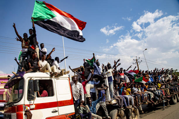
Protesters in Khartoum, Sudan, after the October 25 coup / credit: Revolutionary masses of Sudan
Y.S., Revolutionary Activist
KD: What is your opinion about the recent events in Sudan… Were you surprised by the coup?
Y.S.: The recent developments have done a great service to the revolution. It has expanded its horizon and has reorganized the revolutionary powers around the demands of justice, freedom and peace. This would not have been possible had it not been for the coup, which has lifted the mask on the so-called civilian-military partnership, and it has exposed those who are invested in the concentration of power and wealth in the hands of a certain political elite from both the military and the civilian parties. It has revealed that the conflict is not actually between the civilians and the military—as claimed by the FFC—but it is actually a conflict within a certain political class, unconcerned with the aspirations of the Sudanese people for a civilian rule. Therefore, these recent developments have shown the people who supports their search for justice and who stands in their way toward achieving it, including international organizations, which were never faced with hostility before, but their latest stance in supporting the coup has put them in a position of being a barrier towards justice.
I did not completely expect the coup. It didn’t make sense to me why the military leadership would want to dispose of the civilian partners who were in line with their interests. However, it’s not strange the military has ambitions to be in total control.
KD: Is the civilian component an expression of the aspirations of the revolutionary masses?
Y.S.: The current movement, I believe, is capable of taking down the coup.
KD: What do you think about the position of regional and international powers on the current events in Sudan?
Y.S.: The regional powers intervene aggressively in Sudan to ensure the continuance of previous investments or in hope of newer ones, and to ensure the flow of raw materials and natural resources with no regulation. Sudan is an open battleground for regional and international conflicts to be fought on, amidst a total absence of any national agenda from the civilian and military ruling elites. The regional powers are unconcerned with the aspirations of the Sudanese people, But when there is threat to their interests, it is only logical that they side with the generals, the warlords and some armed militias.
KD: Does the international community have ambitions or interest with the military government?
Y.S.: The international community, by which we mean the United States, is interested in dragging Sudan within the world order of trade agreements and the financial system. It supports whomever achieves those interests. Hamdok, with his background, is the most likely candidate. Since he is part of what is basically a military regime, supporting him is actually supporting military rule.
Kribsoo Diallo is a Cairo-based Pan-Africanist researcher in political science related to African affairs. He has written for many African magazines and newspapers. Diallo has contributed to translated editions of papers and articles in Arabic and English for several research centers within the African continent.
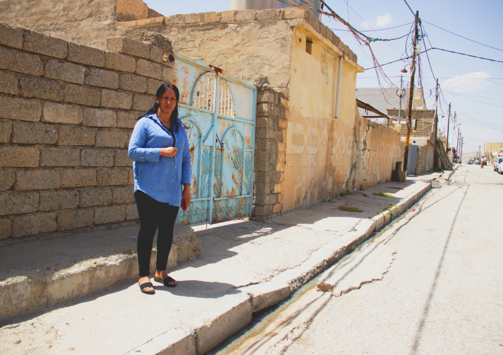
Vian Ramo, a 30-year-old Yazidi, stands in the camp for displaced people in Duhok in Iraqi Kurdistan. She, along with her husband and children, have been displaced since ISIS drove them out of their hometown of Sinjar in 2014 / credit: Alessandra Bajec
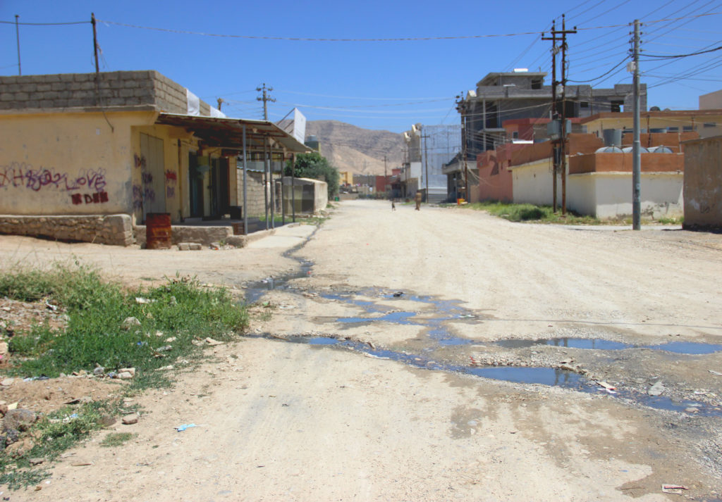
DUHOK, Iraqi Kurdistan—On a warm afternoon, 30-year-old Vian Ramo walked along an unpaved road inside an informal housing settlement in Sharya, a town in the Duhok province. Wearing a denim shirt, black T-shirt and pants, alongwith a little smile on her face, her wide-open hazel eyes had her looking alert and slightly disoriented.
She has been displaced with her husband and two children, ages 6 and 9, ever since 2014. That is when the Islamic State of Iraq and Syria (ISIS) seized Sinjar, a town inside a district of the same name that is home to the ethno-religious Yazidi minority group in northern Iraq. That forced 300,000 Yazidis to flee their homes en masse, facing genocide from the extremist group.
“That night, our neighbors suddenly woke us up saying ‘They [ISIS] are coming to attack us,’” the 30-year-old recounted to Toward Freedom about the day when the group invaded their town after capturing Mosul just two months prior. “I saw many dead bodies then. ISIS forces were in front of us. We left everything behind, jumped in our car and escaped.”
After driving toward the Syrian border in an attempt to take refuge, the four family members ran into unidentified militants who opened fire, pushing them back. Then their car got a flat tire, prompting them to walk to the mountains, north of Sinjar. They stayed for five days without food, water and adequate clothing.
From there, they made another escape through a safe corridor opened by fighters of the People’s Protection Units (YPG), the Syrian Kurdish forces and the Kurdistan Workers’ Party (PKK) fighters. One neighbor gave them a ride in his sport-utility vehicle into Syria to then re-enter Iraq and seek safety in the Kurdistan Region of Iraq (KRI) in the north.
“It’s very difficult for us seeing our people driven out once more,” Ramo sighed, referring to the recent wave of displacement caused by fighting in Sinjar. “It takes us back to those dark, unsettling days.”
In August 2014, the Islamic State swept through northern Iraq, launching a genocidal campaign involving murder, abduction, rape and enslavement, resulting in some 300,000 Yazidis being displaced from their heartland of Sinjar, which spans 2,928 square kilometers (1,131 square miles) in northern Iraq. ISIS considers Yazidis to be apostates—or those who had renounced or abandoned a religion—for following a faith that is similar to Zoroastrianism, a monotheistic religion that originated in Iran.
Yazidis are an ethno-religious community indigenous to Kurdistan, which includes parts of Iraq, Syria, Turkey and Iran. They have settled predominantly in northern Iraq. Many Yazidis claim they are a religious sub-group of the Kurds, while others reject the Kurdish identity, identifying themselves as a separate ethno-religious group. Yazidis have endured persecution at the hands of Arabs, Persians, Turks and Sunni Kurds for their often-misinterpreted beliefs. Though their original language is related to the Iranic language of Kurdish, many also speak Arabic, given their proximity to Arab neighborhoods and Ba’athist Arabization campaigns. They share a strong connection to their lands in northern Iraq, especially around their main temple in Lalish, the holiest site of the Yazidi faith.
A housing complex in the Iraqi Kurdistan settlement of Sharya, where Yazidi people displaced from Sinjar live / credit: Alessandra Bajec
‘When You Have Nothing, You Always Think About Tomorrow’
After staying early on in different unfinished buildings in the Duhok area, Ramo now lives with her family in a one-room concrete house they rent in an informal settlement in Sharya. The structure originally contained no kitchen and the bathroom is outside. The family created a kitchen inside the house using a lightweight panel as a ceiling. Her husband doesn’t have a degree and works as a day laborer. She had never graduated because they fled Sinjar when she was still in high school. That keeps her from finding work, too.
Being on a low, unstable income—and having both kids in school—makes it hard for the couple to make ends meet.
Sometimes, they don’t have enough food to feed their children. Occasionally, they had borrowed money from their neighbors to buy proper clothes for the two and paid them back when they were able.
“We’re barely coping. All Yazidis here suffer from poverty,” the longtime displaced woman complained. “When you have nothing, you always think about tomorrow and how you’re going to pay the rent and bills.” She wishes one day she can resume and finish her studies, then do a degree in nursing or pharmacy and find a secure job.
On the other hand, going back to Sinjar is not an option for Ramo right now.
“ISIS bombed our home—we don’t have a place to stay there,” she said. “If there was reconstruction and security, it would be okay for us to return.”
Then she added without hesitation, her voice sinking low, “There’s no sign that Sinjar will be safe any time soon.”
Fighters of the Sinjar Resistance Units (YBS) in 2017 / credit: Flickr
Thousands Displaced Amid Years of Fighting
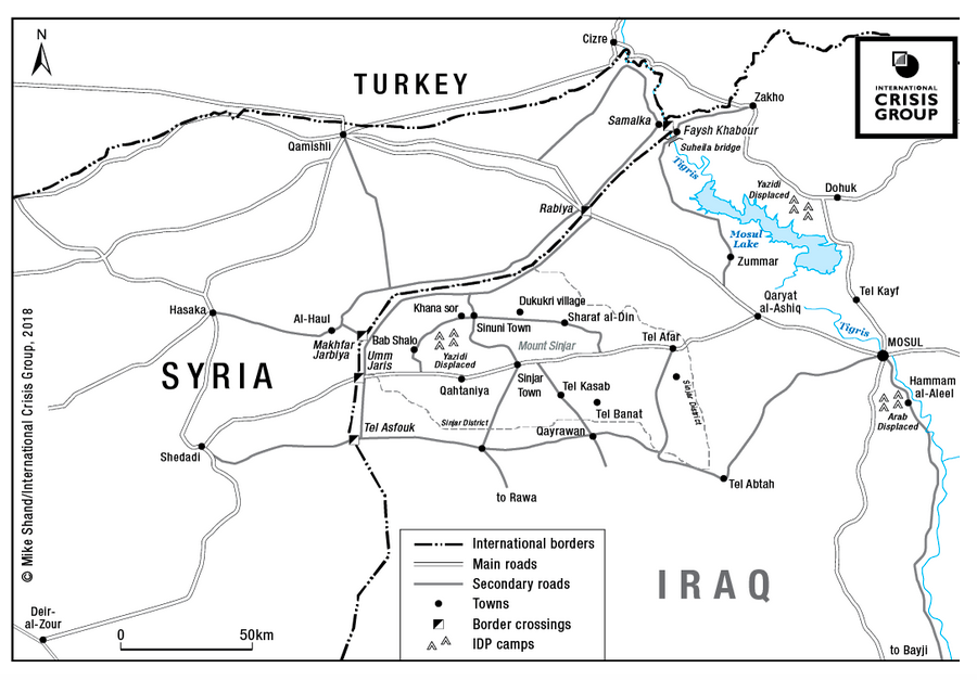
Heavy clashes occurred May 2 and May 3 in Sinjar between the Iraqi army and the Sinjar Resistance Units (YBS) forces as well as Ezidxane Security Forces in the Sinune sub-district of Sinjar over their ties with PKK. That escalation led to a displacement of more than 10,000 people from the district, this being the second or third time they have been pushed out of their homes. In total, 300,000 Yazidi IDPs have fled to Iraqi Kurdistan since 2014.
Since May 2, dozens of people in the Sinjar district have held demonstrations, demanding both an end to the fighting and for armed groups to evacuate towns, as the unstable security situation in the area prevents families from returning to their homeland.
Two-thirds of Sinjar’s population have been stuck in limbo, many of them reluctant to return from camps in KRI, even after ISIS was defeated. Meanwhile, others have gone back in recent years, despite the security risks and challenges they are confronted with at home, such as damaged infrastructure, minimal services, limited livelihood opportunities and little government support.
Amid the chaos, a group of Yazidi women can be found learning skills at the Enterprise & Training Center (ETC) run by the Free Yezidi Foundation (FYF)—a non-profit, humanitarian civil-society organization—in Khanke town, near Duhok. The center mainly teaches crafts, artisan textile production, carpet weaving, and baking skills, along with basic business management and business mathematics. About 100 Yezidi women are trained each year in baking, for instance.
Sitting among the women was Amira Salah, who had just taken part in a knitting session. The 34-year-old came forward quietly, dressed in black pants along with a blue blouse dotted with pink polka dots. She limped with a limb disabled since birth to a different room at the other end of the building.
She and her family are among the thousands of Yazidis who were pushed out of their place of origin in 2014. Their apartment building in Sinjar was destroyed during the ISIS invasion.
“Our home is in ruins until now,” the young woman uttered, lowering her head and skipping instead to recount about her arrival in Khanke, making it obvious to this reporter she was not keen to talk about the ordeal she and her loved ones experienced when the Islamic State attacked the area of Sinjar.
After taking shelter in different places around Khanke, Salah has lived with her mother and two sisters in Khanke camp for internally displaced persons (IDPs) for the last three years.
Like in all camps, living conditions in Khanke are dire. Water supply is inadequate, running every two or three days. Power outages are common, with IDPs staying without electricity for one, two or three days in a row. Dwelling in a 4-meter by 2-meter (13-foot by 6.5-foot) nylon tent, the family is exposed to extreme temperatures in summer as well as in winter.
Only primary healthcare is provided, so the 34-year-old—who has difficulty walking—must find medical assistance outside the camp, which can be unaffordable. “I have to travel to Duhok to get better service and for regular checkups,” she said. “The same goes for one of my sisters who has a speech impairment and my mum who suffers stomach-related issues.”
Managing such a precarious situation for an extended period has been proving for the family of four. “We, Yazidi people, have been helping each other because nobody has helped us during all this time,” Salah emphasized.
Illiterate and unable to access basic education at her age, she recently completed a knitting course at FYF’s training center. From time to time, she now takes home a small amount from selling knitted toys and animals, just to contribute to her family. She is looking for any kind of work she can do to help out more. Her youngest sister, 25, working as a nurse, is the only one at home who has a regular job, earning around $400 a month.
At the moment, Salah ruled out the possibility of returning to her hometown. “I don’t expect Sinjar to be rebuilt, so that people can go back,” she said. Then, without hesitation, she wished aloud, “If only security was restored… at least!”
Then Salah concluded in a gloomy tone, “Sinjar is in such a state that makes you want to stay here.”
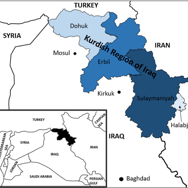
A map showing Iraqi Kurdistan / credit: The Crisis Group
Post-ISIS, Return and Reconstruction In Limbo
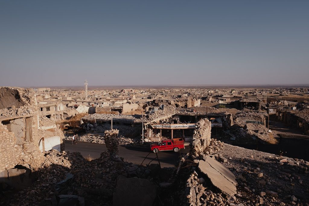
Eight years after the brutal rule of ISIS, much of Sinjar remains in rubble. It lacks schools and hospitals, infrastructure, and other basic services. Thus, jobs are nowhere to be found.
The town lies in disputed mountainous lands in northwestern Iraq between the jurisdictions of the central Iraqi government and the Kurdish Regional Government (KRG). Sinjar’s security situation remains complex due to the presence of different competing armed groups, including the Iraqi military, the Kurdistan Democratic Party (KDP), Patriotic Union of Kurdistan (PUK), the local YBS force and Popular Mobilization Forces (PMF).
Although the federal government and the KRG signed an agreement in October 2020 to preserve security in Sinjar—with Iraqi forces working in coordination with KRG forces—little progress has been made toward implementing it. Moreover, members of the Yazidi community criticized the deal for not including their input.
On top of it, Turkey frequently conducts ground and air offensives in Sinjar against alleged locations of the PKK, which Ankara has labeled a terrorist organization for claiming it has a right to inhabit the southeast portion of Turkey. A U.S. State Department report published early this month stated the presence of PKK-affiliated armed forces—as well as Turkish airstrikes—prevents Yazidi IDPs from going back to the affected areas.
An International Crisis Group report released at the end of May showed the Sinjar agreement has failed to stabilize the area, and that leaving the situation as it is will attract more violence and displacement.
In a meeting with representatives from Sinjar town, a week after May’s confrontations, Iraqi Prime Minister Mustafa Al-Kadhimi said the Sinjar agreement should be implemented. The premier also called on relevant authorities to accelerate the completion of procedures for establishing the Sinjar Reconstruction Fund.
Despite Iraqi forces and the YBS group reaching a ceasefire in early May, Yazidis fear fighting could resume at any time unless a radical solution is found to bring security to the contested district.
A local official affiliated with the KRG declined to discuss the situation of Sinjar after several attempts, and a spokesperson for the Joint Operations Command from the Iraqi Ministry of Defense could not be reached for comment.
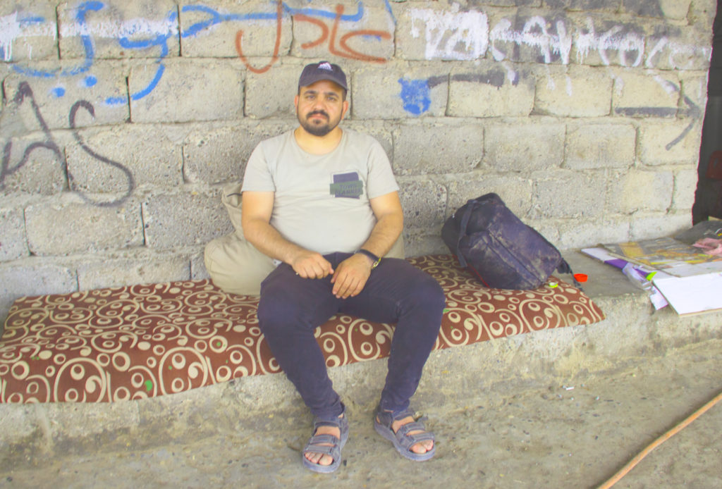
Zaid Hamu, 33, displaced from Sinjar since 2014, at a garage in Khanke in Iraqi Kurdistan / credit: Alessandra Bajec
‘Camp Life Is Miserable’
Hewan Omer, FYF Country Director in Iraq, pointed out lack of safety is the most crucial deterrent against the return of Sinjaris. “There is no governmental entity that locals can rely on. Only militias fighting against each other. People don’t feel safe in Sinjar,” she told Toward Freedom, adding that, because of the ongoing insecurity, many in the community cannot find some reassurance that a genocide will not be repeated.
Hinting at non-functional public water and electrical networks, the country director expressed disappointment about the government inaction in the area, which has hindered Yazidis from rebuilding their lives after years of tragedy, destruction and insecurity.
“We haven’t seen any tangible steps taken to improve security or restore basic services, to incentivize the return of displaced families,” she said.
Khalida Nawaf, ETC’s manager at FYF in Khanke, implied widespread concern exists among Yazidis that the underlying cycle of violence may produce some terrible events again. “None of us can forget that black day when ISIS assaulted Sinjar,” she told Toward Freedom. “Nothing’s been done on the ground, Sinjar is unsafe. We fear another August 3, 2014, could happen.”
Nawaf estimated about 80 percent of Sinjaris have mental health issues as a result of the violence they experienced.
A prominent Yezidi civil-society organization, FYF provides humanitarian support to Yazidi civilians, with a special focus on trauma recovery and psychological services, economic empowerment, community reintegration, and education.
Nawaf noted that both the KRG and the government in Baghdad should coordinate efforts to provide security in the area, proceed with the reconstruction of civilian houses and infrastructure, increase educational establishments, and ensure public services operate normally.
Hanging out in front of a garage in Khanke was Zaid Hamu, 33. He donned a white T-shirt and black trousers, along with a baseball cap.
With his spouse and four kids—between the ages of 18 months and 10 years—the Yazidi man continues to live in displacement after they ran from the ISIS aggression in 2014. “It’s been so long. Eight years!” he exclaimed, talking to Toward Freedom. Then the conversation turned to his fellow Sinjaris, who crossed into Kurdistan last month in the wake of fresh clashes. “Things are going from bad to worse.”
At the time he and his family fled their home in Sinjar, most villagers left in the early morning. He recounted they headed on foot to the southern side of the mountains. They spent nine days there until a corridor was cleared for the evacuation of Yazidi civilians into Syria, enabling them to reach the neighboring Kurdish region and settle in the Khanke IDP camp.
“Our house is still there, but looks like an empty wreck,” the young man said in a bitter tone. “ISIS fighters ransacked it and took everything.”
Like many Yazidis, Hamu is displaced in his own country. A former interpreter for an NGO, he is currently jobless while his wife takes care of the children, meaning no income whatsoever.
“Camp life is miserable,” he uttered. IDPs deal with unbearably hot summers and freezing winters inside tented dwellings. A consistent supply of water and electricity can’t be counted on. The father of four also criticized the quality of education, saying the school where his kids are enrolled is ill-equipped, with overcrowded classrooms. Rotational learning restricts pupils to only attend three days a week.
Then again, restarting his life in Sinjar is unthinkable. “It’s not safe there. There aren’t even the most basic services,” the 33-year-old decried. He held the Iraqi government responsible for doing nothing to secure the area or incentivize the return of displaced Yazidi to their native land.
Looking to seek asylum, he hopes to see himself in any other country. “Nothing holds me here. I’ve had enough,” Hamu said, his face appearing worn out. “I want a better future for my family.”
Map of the Kurdish Region of Iraq (KRI) / credit: ResearchGate
Harsh Living Conditions in Camps
An estimated 300,000 Yazidis remain displaced in Iraq’s Kurdistan region. According to the United Nations High Commissioner on Refugees (UNHCR) in Iraq, fewer than 136,000 individuals are scattered across 15 IDP camps in the governorates (provinces) of Duhok and Nineveh, while another 195,000 live independently in the area.
Inside camps, the majority still live in tents, which makes them vulnerable to harsh weather conditions and fire hazards. They often have little to no access to running water, electricity, heating and sanitation.
Minimal health services are provided, while non-basic medical treatment only is available a few miles away in Duhok. However, many are unable to cover transportation costs to get there.
Schools in IDP camps typically suffer from overcrowding, a lack of basic facilities and qualified teaching staff, which means many schools have to run multiple shifts. Understaffing is supplemented by untrained community members, working as volunteers or for a small stipend, further compromising educational standards.
IDPs rely on the minimum food assistance provided by the KRG and humanitarian organizations. The World Food Program (WFP) distributes food aid in the form of monthly food baskets or cash transfers ranging between 10,000-20,000 Iraqi dinar per month (USD $7 to $14) for each person. However, because of funding gaps, the impact of climate change on global food production, and inflation’s impact on food prices, WFP has stopped financial assistance to all displaced people starting this month. That is, except for in the case of families that can demonstrate their poverty.
For the majority of IDPs who reside outside camps in informal settlements and in urban areas, humanitarian assistance is even less available. They face difficulties in accessing employment that would enable them to meet their basic costs of living, and many can only find casual work, putting large numbers at risk of eviction and/or forcing them to relocate to IDP camps, according to the UNHCR.
FYF’s Omer explained that low education levels, missing documentation, and lack of work experience in sectors other than construction and agriculture limit their prospects. IDPs generally operate fruit and vegetable shops, work on construction sites, or do seasonal farm work for a wage of 7,000 Iraqi dinar (USD $4.8) per day.
View around the town center of Shingal in Sinjar in the summer of 2019 / credit: Levi Clancy / Wikipedia
Obstacles to Returning Home
Throughout the ISIS occupation, 80 percent of public infrastructure and 70 percent of civilian homes in Sinjar were destroyed, according to a report by the UNHCR and REACH, a nonprofit organization that analyzes data on crises, disasters, and displacement.
Last year, the International Organization for Migration (IOM) provided cash assistance to 1,400 families to facilitate the return process.
Beyond that, international organizations have done little to help communities return, whether by repairing basic infrastructure, supporting the local government to ensure provision of essential services, or assisting families in finding sustainable solutions to live in better conditions.
A recent Norwegian Refugee Council (NRC) report found ongoing challenges in accessing housing, land and property rights. Damaged infrastructure, lack of habitable housing, insecurity, and property disputes inhibit displaced families’ return and increase social tensions in Sinjar.
According to the study, 64 percent of IDPs from Sinjar claimed their homes were heavily damaged. For 70 percent, lack of housing and rent increases are the primary source of social conflict among those who have returned. The study relayed 92 percent of returnees reported continued access to their property. In contrast, 99 percent of those who applied for government compensation have not received any funding for damaged property.
NRC urged Baghdad and the KRG to prioritize the rehabilitation of infrastructure and the restoration of services to allow for safe housing, land, and property, alongside public infrastructure. It also called on international development donors to invest in strengthening access to housing, land and property rights to support families in finding solutions for a life back in Sinjar.
“As long as no concrete action is taken in their place of origin, and the situation gets better, most displaced Yazidis are bound to stay here,” FYF’s Omer said, exhaling deeply.
Alessandra Bajec is a freelance journalist specializing in West Asia and North Africa. Between 2010 and 2011, she lived in Palestine. Then she was based in Cairo from 2013 to 2017. Since 2018, Bajec has lived in Tunis.
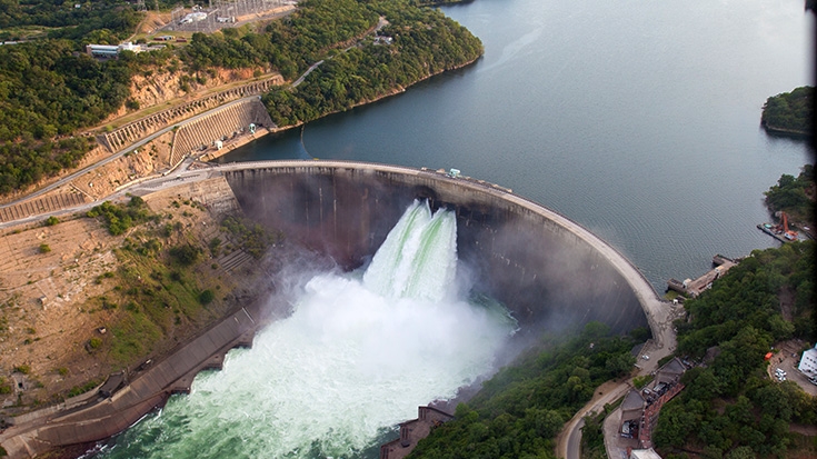
Lake Kariba, the world’s largest dam, was created by stopping the waters of the Zambezi River, which flowed between the southern African countries of Zambia and Zimbabwe / credit: Marcus Wishart, World Bank Group
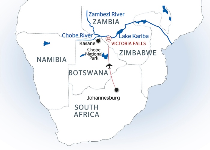
People have lived on both the Zimbabwean and Zambian sides of the Zambezi River of southern Africa for centuries. Their lives revolved around the river. They say their god, the nyami nyami, lives in its waters.
The Zambezi is Africa’s fourth-longest river, flowing from northwestern Zambia into Angola and Botswana, then forming the Zimbabwe-Zambia border, before it empties into the Indian Ocean off Mozambique to the east. For centuries, the people fished in this river, fetched drinking water from it and harvested crops twice a year on its fertile floodplains. As a result, they call themselves basilwizi, which, in their Tonga language, means the “people of the great river.”
Map of Lake Kariba and the Zambezi River’s path through southern Africa / famnews.com
Now, they are only basilwizi in name, with no water to drink or with which to grow crops. They need a government permit to fish on Lake Kariba or on the river further upstream.
“We are just here, thirsty,” BaTonga Chief Saba told Toward Freedom, as he stood in Binga District, Matabeleland North Province located in western Zimbabwe, some 800 km (497 miles) from the capital city of Harare. “Some of us drill boreholes, but even if they drill up to 100 meters (109 yards), they frequently hit dry holes. Where they are lucky to get [water], it will be salty due to the abundance of coal in this area. Come the dry season, the boreholes dry up. Even the hot springs we have yield salty water, as well.”
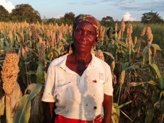
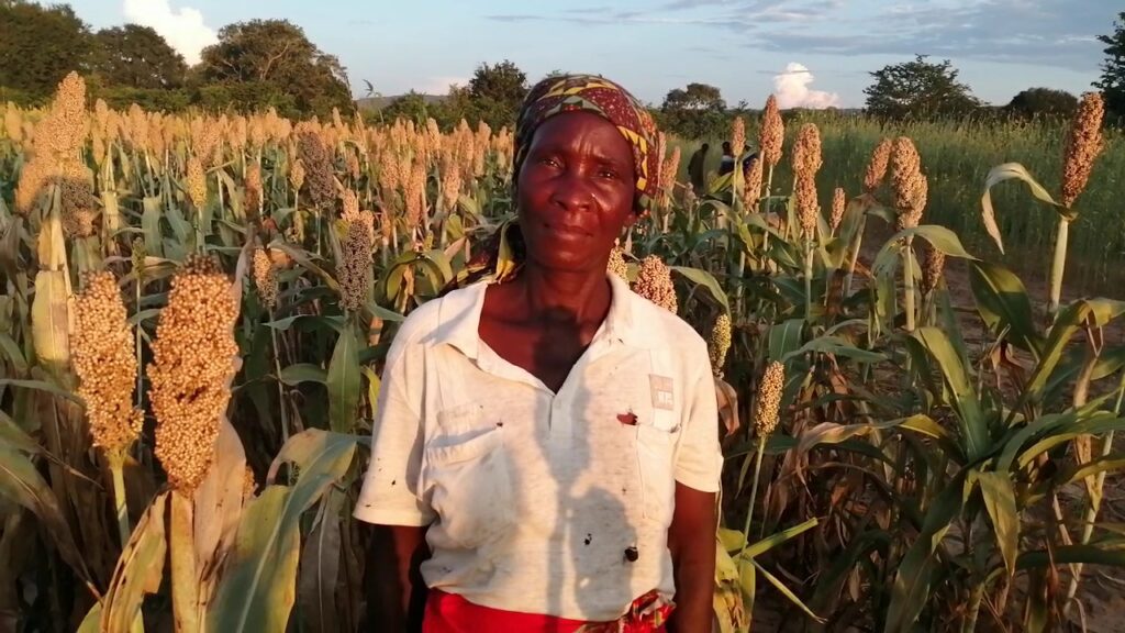
One of 17 BaTonga chiefs in the Binga District, Chief Saba’s parents were among the approximately 23,000 BaTonga villagers displaced from the southern bank of the Zambezi between 1957 and 1962. That made way for the construction of Lake Kariba, the world’s biggest dam constructed by humans. In Zambia, 34,000 people of the BaTonga tribe were removed, too. The 23,000 BaTonga people were scattered in four arid districts in Zimbabwe: Binga, Gokwe North, Hwange and Nyami Nyami. Their population has grown to about 300,000, while displaced in Zambia number 1.3 million.
‘Fish Is Our Gold’
The dam generates electricity that lights up the country. It is home to tourism facilities, as well as to the annual tiger-fishing contest that attracts tourists from southern Africa and beyond. However, the evictees are ranked among the country’s poorest, and trace their poverty to their removal from the fertile shores of the river and to their resettlement in arid places.
“We are people of the great river, so we demand access to it,” Chief Saba said. “Fish is our gold, so we want our people to have special clearance to fish on the lake as their fathers, grandfathers and ancestors used to do.”
“We are people of the great river, so we demand access to it,” said Chief Saba, one of 17 BaTonga chiefs / credit: The Chronicle
Saba added his people want the government and its development partners to build irrigation to help alleviate poverty.
The Zimbabwe Peace Project, a local non-governmental organization (NGO), citing the 2017 Poverty Report by the Zimbabwe Statistical Agency, said Binga was the second highest impoverished district at between 38.4 percent and 51.2 percent. About 50.1 percent of households were classified as “extremely poor.” Food insecurity, as well as lack of access to health, educational and transport services, are rife.
The government is building a $48 million, 42-kilometer (26-mile) pipeline from Deka on the Zambezi River to transport water to cool a 1,500-megawatt, coal-fired power plant at Hwange.
“The pipeline is too far from us,” Chief Saba said. “If we were closer, perhaps we stood a chance of getting some water at communal water points that authorities always set up along such pieces of infrastructure to enable communities to benefit from exploitation of local resources. Because we don’t have reliable water sources, the only alternative is the Zambezi.”
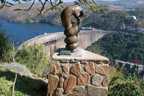
A sculpture of the nyami nyami god overlooking Lake Kariba / credit: Twitter / Destination_Zim
Natural Resources Under Foot
Binga is situated in a coal-rich area. The southern African nation’s biggest coal mine, Hwange Colliery Company Limited, and about a dozen smaller ones, populate Hwange District, Binga’s southwestern neighbor.
The district is blessed with a number of natural resources, such as coal, diamond, gold, lithium, tantalite, timber, wildlife and the Zambezi River. However, the only resources being extracted are coal, timber, wildlife and fish.
“…If one is found fishing illegally, he or she pays a fine worth [sic] $1,500 … failure to do that, they face prosecution.”
The Zimbabwe Parks and Wildlife Management Authority has fixed the fishing permit for people using commercial motorized boats at $1,000 yearly and $300 for those using canoes.
About 57 percent of the land that now sits at the bottom of the lake was arable and owned by the BaTonga, says a Zimbabwean NGO that champions BaTonga rights, Basilwizi Trust, quoting a World Commission on Dams report on Lake Kariba. The document adds that the BaTonga were “‘treated like animals or things rounded up and packed in lorries’ to be moved to their new destination … The racist attitude of the time did not consider the resettlement of Africans as a problem.”
Basilwizi Trust adds:
“The dam’s poor record of resettlement left a huge black mark on the project, which has never been adequately addressed by the parties responsible for building the dam. The colonial and post-independence governments and the major funders and beneficiaries of the dam continue to neglect the relocated people on the Zimbabwean side of the reservoir.”
The trust has demanded reparations in the form of sustainable development programs/projects for the BaTonga and Korekore people in Nyami Nyami District. (While nyami nyami is the name of the BaTonga people’s god, a Zimbabwean district where other BaTonga were forced to move to is called Nyami Nyami. In that district, the BaTonga are called the Korekore people, while in Binga district they are called BaTonga.) The Zambian government compensated each displaced person with $270, but the BaTonga of Zimbabwe were not paid.
A recent paper, “Local knowledge and practices among Tonga people in Zambia and Zimbabwe: A review,” states that prior to the construction of Lake Kariba, the community mainly practiced flood retreat cultivation in their incelela, small plots of land along the riverbank. The mineral-rich soils combined with their system allowed the population to cover their basic needs and harvest twice a year. Now, poverty is widespread among the people.
“Although the dam was built to provide electricity in Zambia and Zimbabwe, up to today, Tonga people have scarce access to electricity,” it adds.
Human-animal conflict is rife in areas where the BaTonga people were resettled to dam the Zambezi River / credit: Basilwizi Trust
Bringing Water to the People
At Dopota Village in Chief Nelukoba’s area in Hwange District, the grievances are the same as those in Binga.
“We have a solar powered borehole in the village, but it is often without water,” Evans Shoko, head of Dopota Village, told Toward Freedom. “We rely on another one that was drilled in 1968 to serve Dopota Primary School, but it is also unreliable due to the general dryness in the area.”
One garden serves 22 out of 36 households in the village. The garden provides just enough vegetables to prepare relish and small parcels to sell to raise just enough money for isigayo. In the local Ndebele language, isigayo is the payment for milling maize, the country’s staple food.
“It is not transformative at all,” Shoko said, “so what the people want is water from the Zambezi for drinking and to support irrigation schemes.”
Shoko’s village is about 5 km (3.1 miles) away from the Deka-Hwange pipeline, so he hoped authorities would set up a point from which villagers could draw water.
The village is less than 6 miles from Hwange National Park. Shoko said animals, especially elephants, stray out of the park to look for food and water in the village, resulting in damaged crops.
“Sometimes they end up killing people.”
Matabeleland North Provincial Minister Richard Moyo said the government is aware of the challenges the BaTonga face.
“We are drilling boreholes in the district and pushing ahead with the Bulawayo Kraal Irrigation Scheme, which will see up to 15,000 hectares (37,000 acres) being put under irrigation,” he told Toward Freedom. The Bulawayo Kraal is about 10 km (6.2 miles) south of the Zambezi River in Binga District.
Moyo said, as of October, the province had drilled about three boreholes out of 17, which are earmarked for chiefs’ homesteads. Last year, President Emmerson Mnangagwa allocated a fishing rig to each of the district’s 17 chiefs, Moyo added. Through this program, the people are able to fish, obtain relish and sell surpluses. Plus, jobs operating the rigs have been created. Moyo said some people in the district would benefit from the Gwayi-Shangani Dam project because of nutritional gardens and irrigation schemes.
“But the issue is not just about water,” Moyo said. “We are building roads, the Binga airstrip is now operational after the government rehabilitated it, so tourism is picking up. Binga Polytechnic [College] enrolled its first intake [of students] last year… So, yes, there are challenges, but we are not leaving Binga behind.”
Thulani Mpofu is a Zimbabwean freelance journalist based in Harare, the capital. He has an interest in development issues. Some of his work has appeared in Canada-headquartered Natural Gas World, Thailand-based Tobacco Asia and South Africa’s Farmers Weekly.