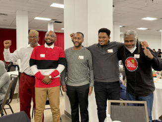
Journalist and activist Elias Amare, U.S./Africa Bridge Building Project Director Imani Countess, American Ethiopian Public Affairs Committee (AEPAC) organizer Elias Hiruy, and medical doctor and #NoMore Movement co-founder Simon Tesfamariam discussed economic development as a human right at the first-ever African Peoples’ Forum. The event was held December 11 at the Eritrean Civic & Cultural Center in Washington, D.C. Journalist Hermela Aregawi and activist Yolian Ogbu moderated.
TF editor Julie Varughese reported on this event being held to counter the Biden administration’s U.S.-Africa Leaders Summit.
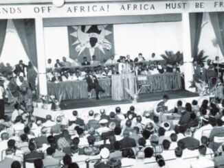
An image of U.S. dollar bills, Canadian dollars, Czech koruna notes and U.K. pound sterlings. Developed countries are required to fund climate-change mitigation and adaption efforts of developing countries / credit: John McArthur on Unsplash
Last month, U.S. Special Presidential Envoy for Climate John Kerry visited India in an effort to bolster the United States’ bilateral and multilateral climate efforts ahead of the 26th Conference of Parties (COP26), which will be held in Glasgow in just a few weeks. Countries that signed the United Nations Framework Convention on Climate Change (UNFCCC) will attend the conference to deliberate as well as negotiate actions needed to combat the climate crisis.
Kerry’s visit to India also marked the launch of Climate Action and Finance Mobilization Dialogue (CAFMD). CAFMD is part of the U.S.-India Agenda 2030 Partnership Indian Prime Minister Narendra Modi and U.S. President Joe Biden announced in April at the Leaders Summit on Climate. The talks took place within the context of India’s membership within an alliance colloquially referred to as “The Quad.” The alliance comprises Australia, Japan, India and the United States, and is aimed at countering a growing China in the Indo-Pacific region.
Soon after Kerry’s visit to India, Quad leaders met at the White House for discussions on a host of issues, including climate change. They agreed to work on climate targets aimed at 2030 and pursue enhanced actions in the 2020s.
But what tools are available to India—and other developing countries—to support them as they face climate-change impacts like eroding coastlines and droughts? And how will such tools be made available?
Mobilizing finance is considered key to helping developing countries meet their emission-reduction targets and adapt to climate-change impacts. At COP15 in Copenhagen in 2009, developed countries committed to a goal of jointly mobilizing $100 billion per year by 2020 to address the needs of developing countries.
But while COP15 set a clear target of $100 billion, it allowed flexibility in terms of what forms of financial support qualify as climate finance. The Paris Agreement, the successor to the Copenhagen Accord, reiterated the $100 billion per year commitment, but it also allows a wide range of financial instruments.
Indian Minister for Environment, Forest and Climate Change Bhupender Yadav (left) and U.S. special presidential climate envoy John Kerry kick off the U.S.-India Climate Action and Finance Mobilization Dialogue on September 13 in New Delhi / credit: twitter/climateenvoy
Developing Countries’ Perspective
Developed and developing countries have different perspectives on climate finance. Chandra Bhushan, a public policy expert and founder/CEO of International Forum for Environment, Sustainability & Technology (iFOREST), explained when developing countries speak of climate-finance requirements, they largely mean public grants from developed countries. But when developed countries talk about climate finance, they mean “everything from loans to grants to bilateral and multilateral funding,” Bhushan said.
Bilateral funding refers to financial support from one country to another. Multilateral funding involves agencies such as the World Bank, which derives its source of funding from multiple countries.
India’s official position on climate finance is only grants and grant-equivalent elements of other instruments, like loans and guarantees, ought to be recognized as climate finance. For example, in a recent interview to CarbonCopy, Rajni Ranjan Rashmi, a former principal negotiator for India at the UN climate change negotiations, said it is “logical” to include only the grant portion, or the concessional part, of the loans in the definition of climate finance.
Publicly available information about CAFMD does not reveal what exactly “financial mobilization” would entail. This reporter filed a Right to Information (RTI) request with the Ministry of Environment, Forests and Climate Change (MoEFCC) for minutes of meetings held between Kerry and the ministry. However, the request was denied.
Bhushan also expressed skepticism, noting how pre-COP launches of dialogues, like CAFMD, are not uncommon. But he said their progress is rarely tracked to ascertain achievements.
Mud cracks formed on a dried-out river bed in the district of Kutch in the Indian state of Gujarat / credit: Renzo D’souza on Unsplash
Unpacking “Finance Mobilization”
In general, “finance mobilization” can happen on both concessional and commercial terms. Arjun Dutt, program lead at Council on Energy, Environment and Water (CEEW) said concessional capital typically is channeled through grants and soft loans to market segments that are not commercially viable to catalyze investment. And as for finance on commercial terms, Dutt noted it typically flows into sectors that have achieved commercial viability and large-scale deployment, such as utility-scale renewable energy.
Elaborating on what India needs, Dutt said if the world wants India to decarbonize at an accelerated pace and commit to net-zero goals, the country “would likely require greater international [climate-finance] flows on both concessional and commercial terms.”
Through financial instruments such as guarantees, concessional capital could help lower the risk of loan defaults with new clean-energy technologies, which could catalyze more private-sector investments, Dutt explained. And as for commercial international capital, it would be needed because of the sheer scale of India’s decarbonization requirements.
Pays to note, in her meeting with Kerry, Indian Minister of Finance and Corporate Affairs Nirmala Sitaraman also underscored a need for enhanced climate finance for developing countries, or funding beyond the $100 billion commitment made at the Copenhagen summit.
Recently, even African nations called for a 10-fold increase to the $100 billion climate finance target.
Climate Finance’s Track Record
Developed countries have largely failed in fulfilling their climate finance obligations, a September 2021 report shows. Out of 23 developed countries that have a responsibility to provide climate finance, only Germany, Norway and Sweden have been paying their fair share of the annual $100 billion goal. More specifically, it states that the United States has the biggest shortfall in paying its fair share of climate finance, based on historical emissions and national income.
Drought in Ooty, a town nestled in the Western Ghats mountain range in the Indian state of Tamil Nadu / credit: Shravan K Acharya on Unsplash
And closer examination of delivered climate finance reveals other issues. According to a report by Oxfam, the share of grants in global public climate finance was only 27 percent in 2019, whereas loans—both concessional and otherwise—totaled 71 percent. The remaining 2 percent comprised finance mobilized from private sources. Oxfam referred to this reliance on loans to fulfill climate-finance obligations “an overlooked scandal.”
Recently, a climate negotiator from a developing country, who anonymously wrote for The Guardian, pointed out how climate finance in the form of loans is creating a debt trap for countries in the Global South, where the COVID-19 pandemic has hit economies.
Interest rates on concessional loans are unequal, too. “The rate of interest in developed countries is around 2 percent and in India, it is around 14 percent,” said Bhushan of iFOREST. “So, if the United States gives a loan for 6 percent, will you consider it as a loan given on concessional terms?”
Funding Mitigation Versus Adaptation
Climate finance usually aids two solutions: Mitigation and adaptation. Mitigation refers to efforts aimed at reducing greenhouse-gas emissions like investments in renewable energy technologies or even making existing energy generation more efficient. Adaptation means remodeling and reorganizing society and the physical environment to address risks posed by climate change. Climate adaptation includes enhancing the resilience of coastal communities with nature-based solutions like restoration of mangroves and providing food security with climate-resilient agricultural practices.
Here, too, disparities exist between the needs of developing countries and what the developed world actually delivers.
Little doubt remains that climate change disproportionately impacts the Global South, given pre-existing conditions like food insecurity and lack of adequate healthcare. And so, countries in this region need as much financial support, if not more, for adaptation as they do for undertaking mitigation measures to arrest the global temperature rise. Even the Paris Agreement recognizes developing countries need equal amounts of funding towards mitigation and adaptation. But funding flows largely towards mitigation.
Oxfam points out 66 percent of global public climate finance supported mitigation while only 25 percent went toward adaptation. “Profitability drives the flow of money,” Dutt said, noting how climate finance goes toward mitigation efforts—like enhancing deployment in the renewable energy sector—and not to adaptation. But this is where public finance—or that which is provided by taxpayer money—can flow.
It also is unclear if developing countries have undertaken climate-change impact assessments and drafted clear policies aimed at mitigation, which could then be implemented using international climate financing.
Solar Power Plant Telangana II in the Indian state of Telangana / credit: Thomas Lloyd Group
Developing Homegrown Climate Technology
Article 4.5 of the UNFCCC states developed countries have undertaken a commitment to
“take all practicable steps to promote, facilitate and finance, as appropriate, the transfer of, or access to environmentally sound technologies and knowledge to other Parties, particularly developing country Parties, to enable them to implement the provisions of the Convention.”
But little clarity is available on what “practicable” entails, what “as appropriate” means and what “environmentally sound technologies” encompass.
More rudimentary questions exist about whether developing countries like India need technology transfers.
“Renewable energy technologies like modules and inverters are produced at a mass scale across the world and even in India. These technologies are well-understood,” Dutt said. The only challenge, Dutt added, is India has not been able to produce renewable-energy equipment at globally competitive rates.
Expressing similar concerns, Bhushan spoke of how technologies like solar photovoltaic (PV) panels have hundreds of parts and algorithms that could have hundreds of intellectual property rights (IPRs). “Many of these IPRs are from developing countries themselves,” he noted. These IPRs are then packaged together and sold to companies to manufacture solar PV modules and panels. “Technology transfer is not like giving a formula to someone to produce a chemical. It is a combination of hundreds of formulas, many owned by Indians themselves,” Bhushan said. “The bottomline is, if you have money, you can buy whatever technology you want.” And so, the issue is not about freeing technology, like with the COVID-19 vaccines.
India has largely handled its own mitigation pathway because the country has access to renewable-energy technologies—both imported and domestically produced. Bhushan said talk of technology transfer is largely rhetoric without substantive demands detailing what exactly developing countries need.
Rishika Pardikar is a freelance journalist in Bangalore, India.
Editor’s Note:This article, originally published by Unbias the News, is part of the Sinking Cities Project, which covers six cities’ responses to sea-level rise. The investigation was developed with the support of Journalismfund.eu, European Cultural Foundation and the German Postcode Lottery.
In order to visit Alexandria’s most famous museum, you need to dive into its sea. Much of this ancient Egyptian city was lost to sea, and sank beneath the waves of the Mediterranean around the 3rd or 2nd century.
Located 2.5 kilometers (1.55 miles) off the coast of Alexandria, “Abu Qir Sunken Cities Museum” hosts the underwater ruins of both the Thonis-Heracleion and Canopus cities, where visitors can see the lighthouse that was one of the world’s Seven Wonders, along with anchors, gold coins, and the remains of the palace where Cleopatra and Anthony lived their last days, all lying at the bottom of the sea, as a testament of how vulnerable humans are to nature’s forces.
Since the discovery of the two long-lost cities and other underwater sites, scientists and researchers have been striving to unravel the reason behind the collapse and submergence of these great cities more than 1,500 years ago. They are also investigating the probability of history repeating itself.
Historical Precedent
Franck Goddio, the French underwater archaeologist who, in 2000, discovered the city of Thonis-Heracleion said that parts of the city’s ancient coastline sank beneath the sea “due to a combination of natural phenomena, including a series of earthquakes and tidal waves.”
Spending most of his long career studying ancient Alexandria, Magdy Torab, professor of Geomorphology at the Faculty of Arts, Damanhour University, suggests the same reasons for what happened there. “Alexandria is located close to some active tectonic plates, we witness a lot of earthquakes from near and distant sources that caused damages to the city, both in historical and recent times. One of the effects of those land movements is causing land subsidence,” he said.
In a study published by the Austrian Academy of Sciences Press in 2018, Torab also investigated sea level variation at Alexandria over the last millennia. “There is an abrupt relative sea level rise that occurred from the mid-8th century to the end of 9th century that explains the wide movement of sinking that happened at this time.”
Exploring the different reasons that led to the disappearance of this coastal city has a special importance as it is used by scientists to predict earthquake hazards in the coastal areas today.
Torab describes the effect of the seismic activities that the ancient city of Alexandria faced at this time, “land may have subsided as a result of an earthquake that followed an undersea earthquake or tsunamis.”
Land subsidence is a gradual or sudden sinking of the earth’s surface. The phenomenon can be caused by many reasons. Some of them might be related to human activities or part of a natural process like earthquakes.
The Mediterranean region has a witnessed many destructive earthquakes, among them the 365 Crete earthquake, which happened between the fourth and sixth centuries and was followed by a devastating tsunami that swept out Alexandria, and the Nile Delta, killing thousands.
So the great port that hosted the legendary Alexandria library flooded by a giant wall of water that puts big parts of the city under the water. Does this indicate that this might happen again?
According to the UNESCO, Alexandria is among five cities in the Mediterranean sea that is under the threat and need to be “tsunami-ready” by 2030. “Statistics show that the probability of a tsunami wave exceeding 1 meter in the Mediterranean in the next 30 years is close to 100 percent.”
Between the Sky and the Sea
Ziad Morsy knows Alexandria by heart. That’s hardly surprising, considerings he and his ancestors have lived in the city for decades. But what is remarkable is how much he knows about the invisible part of Alexandria, the part settling underwater.
For more than 12 years, Morsy’s work was under the water, as a scholar at Alexandria Centre for Maritime Archaeology and Underwater Cultural Heritage, then a visiting Lecturer of Maritime Archaeology. His job was to dive in the sea and collect data, because, as he said, “to be prepared for the future we need to understand the past”.
“Global warming will definitely affect Alexandria’s shoreline. But is it going to be the reason behind its sinking? I don’t think so. From my point of view, there is a long list of reasons, and global warming comes at the end of this list,” Morsy told Unbias the News.
He summarized the factors that determine “whether Alexandria is going to stay above the water or sink under the water” in three points: The city land level, the Mediterranean sea level, and Lake Mariout.
Geographical Precarity
If you search for Alexandria in the map, you will notice the port’s unique location, at the western end of the Nile River Delta and between two water bodies: the Mediterranean Sea in the north and Lake Mariout in the south.
The lake, which used to be much larger, is filled with brackish water because it receives a large amount of sewerage output and discharge of untreated irrigation wastewater that comes from the western delta. Although it connects to neither the Mediterranean Sea nor the River Nile, in order to keep the water level in this landlocked lake below sea level, water gets pumped and discharged from the lake into the sea.
“Imagine if the pumps didn’t work for any reason, the water level in the lake would increase and overflow, which means that parts of southern Alexandria would be flooded by the water,” said Morsy, citing another infrastructure risk.
Morsy believes that researchers are turning their heads toward the sea level rise effect, when the real focus should be on the land of Alexandria:
“A tsunami will not remove Alexandria from the map. Tidal waves will certainly cause damage. But what will swallow this city are earthquakes and land subsidence. We will go down to the bottom of the sea, just the way it happened before.”
The Mermaid of the Mediterranean
The spot where Alexandria was constructed is playing a vital role in the city’s sinking scenarios. It dates back to 331 B.C, when Alexander the Great chose to build a city surrounded by two water bodies: the Mediterranean Sea in the north to make it a trade center, and Lake Mariout to the south, where he directed the Greek architect Dinocrat to design “Alexander’s Harbor.”
But the chosen location was a barren area. So the engineer needed to establish a complex, intelligent system to supply water from the Nile through canals, and then distribute water through a branched pipeline system and store it in underground tanks.
Parts of this old pipeline system still exist but are not functioning, as the new city is built on the top of the many ancient cities that came ahead of it, “And this is in itself another cause of subsidence,” said Torab.
“If you are living in Alexandria, it will be normal for you to suddenly pass by a big hole in the middle of a road you are used to walking on every day, or see a building with visible cracks. It is an obvious form of land subsidence,” Morsy said.
Building with cracks and damage, a common sight in Alexandria / credit: Rehab Abdalmohsen
This issue inspired the Goethe Institute in Alexandria to join the project “Atlas of Mediterranean Liquidity,” which aims to show the impact of climate change on the Mediterranean through interactive maps and artwork.
Morsy contributed to the project. He sees it as a good way to raise awareness on how the city water sector was historically managed, and the challenges the city is going through. All is done through an interactive map done based on historical maps and city plans.
The ancient Alexandria was also built on limestone coastal ridges covered by a layer of clay, then a layer of the Nile river silt accumulated through the years. These landforms added to the fragility of the land toward subsidence, Morsy explained. The ancient Alexandria was also built on limestone coastal ridges that were covered by a layer of clay, then a layer of the Nile river silt that was accumulated through the years and these landforms added to the fragility of the land toward subsidence, Morsy explained.
Land Regression
Before reaching the Mediterranean, the Nile divides into two branches, Damietta and Rosetta. The number of branches is not clear, but they used to empty themselves in the Mediterranean Sea. One went through Alexandria even during the time of Queen Cleopatra. The blockage of the “Canopic branch,” due to the lack of maintenance, affected the sediment supply to the delta and the shoreline, which was vital for compensating the soil that got swept away by the waves, and caused land regression.
“Since the construction of the High Aswan Dam (HAD) across the Nile at Aswan in 1964, fresh water and sediment delivery to the coast of Alexandria declined every year. Because of the absence of sediments, the rates of soil erosion, land subsidence and groundwater salinity increased. This led to losing some lands to the sea, and we will be losing more,” said Ahmed Radwan, professor at National Institutes of Oceanography and Fisheries of Egypt (NIOF).
Daniel Jean Stanley and Andrew G. Warne published a well-recognized paper, “The Sea level and Initiation of Predynastic Culture in the Nile Delta.” They mentioned that, since 1964, essentially no sediment has been transported by the Nile River to the coast and also concluded that the Nile Delta “… is no longer an active delta but, rather, a completely wave-dominated coastal plain along the Mediterranean coast.”
He added that, without this dam, Egyptians would have survived neither the Nile flood, which killed hundreds of souls, nor the drought that hit the east African countries in the late ’80s and early ’90s: “The HAD was the real engine behind the development that happened in the country at this time.”
Land Reclamation
Radwan lives in Alexandria. He witnesses the coastal protection project that gets implemented by the government every day, and researches many hot spots. He believes the government’s reclamation and nourishment efforts are the safeguards for much of the coastland we are witnessing today:
“Let me give you an example. Abu Quir bay Headland is gained from the sea. Without the governmental effort to fill the gap in sediments, the area would have been lost to the sea. This is why sand feeding is important – to compensate for what nature was doing and bring in some ecological balance to the area that was lost to the sea with soil, cements or rocks.”
Between 1987 and 1994, artificial beach nourishment projects were implemented at Abu Qir, Stanley, El Asafra, Mandara and El Shatby beaches, with and without concrete jetties.
According to the UNESCO report, every year, 20-ton blocks are dumped into the water to protect the Corniche (road built along a coast) wall from wave action and seasonal winter floods.
Blocks line the beach in Alexandria / credit: Rehab Abdalmohsen
“Land nourishment is not a permanent solution,” said Hisham Elsafti, who participated in the design and evaluation of many projects in marine civil engineering in Alexandria as a researcher at Alexandria University.
Elsafti works for the Department of Hydromechanics and Coastal Engineering at Leichtweiß Institute for Hydraulic Engineering and Water Resources of the Technical University of Braunschweig in Germany. He explained that “soft” solutions like beach nourishment might be more favorable because the global direction nowadays is to implement an Integrated Coastal Zone Management (ICZM). It is an interdisciplinary, iterative approach for sustainable use of the coastal zone combined with nature-based solutions, sometimes also referred to as building/engineering with nature.
He gave an example of nature-based solutions supporting local coastal ecosystems to protect the coast, “in Indonesia, the country is using mangrove forests to dampen tsunamis’ damage to its coast.”
Hard and Soft Solutions
In 1984, the American engineering services company Tetra Tech, Inc. developed a Shore Protection Master Plan (SPMP) for the Nile Delta Shoreline and Alexandria for the Shore Protection Authority (SPA) of Egypt. It designed specific schemes for 13 selected shore protection projects, which were then categorized as “first priority projects,” and “second priority projects.”
The solutions applied by the Egyptian government are mostly “hard engineering solutions.” It is a well-known technique to protect its shoreline by placing coastal concrete armor units that change the patterns of seabed erosion and siltation for a long distance along the shore, as Elsafti said.
Before the soft and hard engineering solutions, Alexandria used to get its shore protection from two natural sources, the long shore parallel breakwater called “Pharos Island,” an island composed of a series of ridges. The Nile and the Litani—especially the Nile river—were significant in supplying sediment along the shore and filling the deficiency in the coastal sediment budget.
Humans tried to mimic those natural islands, and make artificial islands through land reclamation. Part of the supposed benefits of those islands is protecting the main shoreline. The government reclaimed a big part of the shore in Alexandria. In the north coast, and in Al-Alamein city to the west of Alexandria, a big project of land reclamation took place, aiming to build more than 25 high buildings, each including more than 41 floors.
“The benefits of those projects are economical but their relation to coastal protection is limited,” said Elsafti who also explains how any human interference in nature should be studied well, in order to avoid fixing a problem in one location only to cause problems in others.
He added that if sand nourishment is done at a place in the sea where the sand doesn’t belong, then the sand will shift from that spot, and sediment in another. “This is why any sand nourishment project takes into consideration the annual sand feed process.”
The Shore Protection Authority released a report titled “Adaptation to Climate Change in the Nile Delta through Integrated Coastal Zone Management.” It mentioned that “even if these measures—of coastal protection—were fully in place some of them may eventually prove to have negative impacts without a proper understanding of longer-term coastal dynamics associated with climate change. Therefore, more complex (mixed) approaches are required to increase the robustness of the coast and ensure sustainable long-term adaptation.”
Unlike the old city of Alexandria, the new Al-Alamein is considering coastal protection mechanisms throughout the construction process. During my visit to the place, I witnessed the large scale of engineering coastal protection work even before the completion of the construction.
The IPCC (Intergovernmental Panel on Climate Change) Special Report on the Ocean and Cryosphere in a Changing Climate (SROCC) mentioned that the Egyptian government has committed $200 million to hard coastal protection at Alexandria and adopted integrated coastal zone management for the northern coast, including jetties, groins, seawalls, and breakwaters to combat beach erosion. “Recent activities include integrating SLR (sea level rise) risks within adaptation planning for social-ecological systems, with special focus on coastal urban areas, agriculture, migration and other human security dimensions,” says the report.
Lack of Coordination
Working as climate change advisor at the technical office in the Ministry of Environment and Environmental Affairs Agency has given Nadia Mohamed Elmasry a chance to witness what is happening on the ground to save Alexandria from sinking.
In 2017, she was involved in a project with the Public Authority for Shore Protection on a project to map the hotspots that urgently need the construction of tide breakers, to decrease erosion in these areas.
“After finishing the study, we noticed that some spots got eroded more than our expectations. Does this mean that the study was wrong? No, there were some unplanned development projects not included in our study, and they were built without considering the erosion map, such as the North Coast Compounds and new Al-Alamein.”
This explains why the beach looks different before and after the establishment of the compounds oin the north coast. “Before the construction you could see a sandy, beautiful beach. But after it you will notice the sudden appearance of a rocky beach,” said Elmasry.
She explained this normally happens when extensive engineering projects take place in the sea—such as those undertaken to create yacht marina or jetties—without studying the erosion rates, the shoreline change pattern and the tidal movements. These affect the tides’ direction and the erosion pattern, and cause high erosion rate in one place and increase in sedimentation in another one.
Elmasry opened the map and pointed her finger at the coastline of Alexandria and northcoast and said:
“Look at this shoreline. Some spots here were under high threat, but the situation in those spots improved a lot. Unfortunately some other spots deteriorated. I believe it’s not because of the lack of environmental studies, but the lack of cooperation between the different entities.”
The Egyptian government is facing this threat from many quarters. At the top of the list come the Egyptian Coastal Research Institute and the Egyptian Public Authority for Shore Protection, whose roles are to monitor the evolution of the Egyptian coasts to determine the near shore zone changes of the coasts. They predict future changes in the coastal zone by using mathematical models to select the most economical and effective protective measures.
They also prepared the Alexandria Integrated Coastal Zone Management Project (AICZM) under climate change scenarios, along with other entities such as the Egyptian Environmental Affairs Agency (EEAA) which, they say, is providing the most efficient, low cost and effective control works to protect the heavily populated areas.
Who Can See the Sea?
Alexandria has gone through many phases of abundance and deterioration throughout its modern history. The city lost its prestigious place and importance as a cultural and commercial center, and its population notably declined. It happened just before the earthquake that hit the city and caused big damage to its infrastructure and buildings, including ruining the lighthouse around 956 AD.
But gradually the city regained its place. Now it is facing the opposite problem. An over-growing population shrunk the space for houses, which encouraged the construction of tall buildings by the seaside. Many cafes and restaurants sprung up on the now-concrete shore, and together all these structures added big pressure on the infrastructure and the land.
If you plan to visit the remarkable coastal city, there is a high chance you won’t be able to see the sea, or sit on a sandy shore. The coastline mostly consists of big blocks of concrete to protect the shore from erosion, with either cubic shapes or four-legged quadripods, or restaurants and cafes that will stand as a barrier between you and the sea view.
Elsafti clarified that coastal defenses along Alexandria’s coast were developed to support the widening of the Corniche by means of a revetment structure. These sloping structures erode the power of the waves behind them, but it is not related to SLR. “Revetments should be designed to prevent the seepage of fine soil material from the large gaps between the coastal concrete armor.”
He described how hard it used to be to move from one place to another using the Corniche road before the widening, and the shore nourishment that had been done years ago, “Traffic used to be a nightmare. The Corniche widening project helped a lot in facilitating the movement.”
Yasmine Hussein is a research director at the Human and the City for Social Research (HCSR), and her family members are old residents of Alexandria. Before talking about the city, she took a deep breath and, with a voice full of sadness, she said: “Yes, there used to be sand and shores, and walking on the Corniche was a basic outing for Alexandrian families. I built hundreds of sand castles just like all kids my age at the time. Those childhood memories are gone, and now, there is almost no shore. There are either concrete blocks, or restaurants and cafes constructed on the shore. The generation that witnessed Alexandria 15 or 20 years ago is feeling a great amount of sorrow and nostalgia.”
People sit, fish and relax on concrete blocks lining the seaside in Alexandria / credit: Rehab Abdalmohsen
Hussein contributed to many studies about Alexandria. One of them is “Alexandria Corniche: Between privatization and the right to see the sea,” which investigated how the highly populated city of Alexandria, with its more than half a million inhabitants nowadays, lost most of its shores. She attributed this loss to the urbanization projects implemented without enough consideration to the environment, or before the completion of the project’s environmental studies.
“The threat comes not only from sea level rise but other factors, such as land subsidence and the threat of earthquakes. This is what happened in the past and led to the sinking of this city twice, in 956 AD and 1303 AD,” said Hussein.
“We are inside the climate change, not waiting for it to happen,” Hussein added with a strong voice, “We used to have seasonal rain in the winter. It is locally called ‘NOAA’. It is more intense now. The rain is heavier, the storms are faster, and the tides are higher. This situation is causing damages; almost every year we are witnessing (extreme weather events).”
She explained that Alexandria faces two challenges. The first is repeating the same scenario and sinking again by tsunamis or earthquakes, and the second is the seasonal sinking every winter because of the extreme weather events.
One of the challenges that adds to the fragility of the city is the heavy construction and housing projects that took place everywhere: “This is a heavy weight on the land. It is an unbearable load … that doesn’t consider the environment or climate change.”
This increased privatization also takes a toll on public space. In 2019, the research center HCSR launched a campaign called, “Alexandria can’t see the sea,” to create awareness and encourage communities to get involved and be aware of the situation in their city before it’s too late. Hussein recalled, “We received good feedback from the community members. We asked people to send photos of the sea view to compare between the view in the past and now, collected those “before and after” photos, held an exhibition where we showcased what is going on the ground, and presented our studies.”
Top of the List
In their annual report, the IPCC said that “in the absence of any adaptation, Egypt, Mozambique, and Nigeria are projected to be worst affected by sea level rise in terms of the number of people at risk of flooding annually in a 4℃ (39.2°F) warming scenario.”
The report explored the potential damages due to SLR and coastal extreme events in 12 major African cities. The city of Alexandria in North Africa leads the ranking, with an aggregate expected damage of $36 billion and $50 billion under the moderate scenario, where emissions peak around 2040 and then decline.
The Egyptian Ministry of Water Resources and Irrigation reports a sea level rise at an average rate of 1.8 mm (0.7 inches) per year until 1993. The following two decades, the water level rose by 2.1 mm (0.8 inches) per year, and since 2012 it reached 3.2 mm (0.12 inches) per year. The Nile delta is reported to sink at the same rate, which amplifying the negative impacts of SLR.
But Morsy believes that a satellite view might not give the most accurate data regarding the effect of SLR in Alexandria, “We need studies that will focus on small scales and local environmental aspects and their effects. The effect of climate change and SLR is not equal everywhere in Alexandria.”
Morsy agreed that sometimes researchers focus on the worst case scenarios to encourage governments to take actions: “There was an old study that predicted that Alexandria will sink in 2023. But look how the situation is now; the city didn’t sink.”
He said that if the city is going down it’s because of all the factors that get mentioned:“Every thousand years the city goes down by one meter.”
Morsy leaves me to dive again and swim beside the ancient Alexandria. His dream now is to live on a ship in the Nile in Aswan, so that if a flood happens he will be safe in his Ark.
Rehab Abdalmohsen is an independent science journalist and water reporter whose work has appeared in ScieDev.net, @NatureNews, the Niles magazine, among others.
Eric Agnero joined Toward Freedom‘s board on May 14. He is a journalist and political analyst from the Ivory Coast, specializing in U.S.-Africa affairs. At CNN, he covered the 2010-11 Ivorian post-electoral crisis as a West Africa correspondent. He also has reported for Voice of America in Washington, D.C. Having experience in corporate and state-run media outlets has helped Eric understand the gap they leave behind for ordinary people. Aside from his journalistic experience, Eric has worked as communications director at the African Union. Having first moved to Vermont in 2012, he recently returned after several years working for organizations in Africa. Eric now is involved in community media projects with the Association of Africans Living in Vermont, Media Factory, CCTV Center for Media & Democracy, and Vermont Institute of Community and International Involvement.
Here’s what he had to tell Toward Freedom about the role of the media and what’s next to cover in Africa.
What got you interested in joining Toward Freedom’s board of directors?
I started by writing about Africa for TF. Then I realized that my stories could miss authenticity as I am far away from the continent, and could no longer navigate accurately the facts and nuances. I thought it would make more sense for me to be in a position where I can foster a better ownership of the generation of stories about the continent by the journalists on the ground.
You started off working in U.S. corporate and state-run media in the 1990s. How did those experiences develop your understanding of how the media influences public opinion?
Working on that side of the media spectrum has given me the advantage of measuring the impact, as the media in question have a well-defined purpose for which they will constantly re-adjust, especially regarding the subsequent inclination or realignment of the target audience.
What are most media outlets missing when it comes to covering Africa?
When it comes to Africa, most media—especially from the Western world—cannot depart themselves from the Judeo-Christian/Caucasian supremacy philosophy. Africa is always treated by the Western world as the poor infant that needs food, clothes and education. And most Western journalists orient their story with that idea of a plagued continent, where there will always be a dictator who maintains their people in poverty. This might be right, but they fail to report that the former colonial powers and the United States groom most dictators. But, most importantly, that the state of the African continent is in large part the result of Western malign influence and the continuing dwelling of the spirit of the 1884-85 Berlin Conference.
What story should Toward Freedom cover that corporate media has ignored?
The corporate media doesn’t cover the stories of those who are fighting to unroot the colonial and imperialist powers from the continent. The stories of successes in alternative economic, political, and social endeavors that are re-writing history and projecting the so-called “dark continent” of Africa into a bright future. Toward Freedom should therefore hear the stories of journalists from Africa who are part of this movement.