As anger over incoming tax hikes boils over in Kenya, African Stream takes a deep dive into the role the International Monetary Fund (IMF) has played in ramming austerity down Africans’ throats. It boils down to neocolonial debt slavery, a system designed to oppress Africans, while oiling the wheels of otherwise faltering Western economies. African Stream’s Kenneth Kaigua breaks down this complex issue.
Related Articles
Related Articles

Sanctions Pressure Sticks Serbia Between Western Hammer and Russian Anvil

Only a handful of European countries have refused to impose sanctions on the Russian Federation after the United States called for them once Moscow’s “special military operation” in Ukraine began on February 24. Serbia is one such outlier. As a result, the West is pressuring the Balkan nation to change its foreign-policy vector and pick a side in the Russo-Ukrainian conflict.
Ever since the war in Ukraine broke out, Serbia has been trying to preserve its neutral position. Belgrade condemned the Russian invasion, but did not join in on anti-Russia sanctions. That led Moscow to keep Serbia off its list of “unfriendly countries.” That means the Balkan nation—unlike European Union members—can continue purchasing Russian natural gas and oil in U.S. dollars, rather than opening ruble accounts at Gazprombank, a privately owned Russian bank. The problem, however, is the EU could indirectly punish Serbia for not imposing sanctions.
According to reports, transport of crude oil from Croatia for Serbian oil corporation Naftna Industrija Srbije (NIS) will cease May 15 due to the EU’s sanctions against Russian companies. Russia’s Gazprom Neft owns 56.15 percent of shares, while the Serbian state owns 29.87 percent. The fourth package of EU sanctions prohibits European companies from cooperating with a number of Russian companies, including Gazprom Neft and its subsidiaries, in which Russia has more than 50 percent ownership.
Getting Around Sanctions
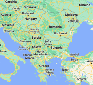
What are Serbia’s options? According to Jelica Putnikovic, editor in chief of the Energija Balkana web portal, the alternative to oil supplies from Croatia is transporting crude oil by rail from the Adriatic ports of Durres in Albania and Bar in Montenegro, or by barge from the Greek port of Thessaloniki and the Black Sea port of Romania’s Constanța.
“It is, however, a longer and more expensive transport. The good thing is that Romania and Bulgaria still have not announced that they plan to impose similar sanctions on NIS, which opens the possibility for various oil deliveries to Serbia,” Putnikovic stressed in an interview with a Serbian publication. Her analyses show Serbia produces about 23 percent of its oil needs, while 45 percent of imports come from Iraq, 10 percent from Kazakhstan, 1 percent from Norway and about 16 percent from Russia. Russian gas is relatively cheap for Serbia. It costs $270 per 1,000 cubic meters, while gas prices broke all records at the end of February in Europe and reached $3,900 per cubic meters.
“For us, oil and gas supplies are the most important issues,” Vladimir Djukanovic, a Serbian lawmaker and the top official of the ruling Serbian Progressive Party (SNS) said in an interview with Toward Freedom. The SNS won the majority of parliamentary seats in elections held Sunday, and the party’s leader, Aleksandar Vucic has been re-elected for a second presidential term.
Djukanovic claims Serbia—despite strong pressure from the EU—does not intend to join anti-Russia sanctions.
“If the EU decides to impose energy sanctions on Russia, then we can think about joining sanctions,” Djukanovic added.
Despite sanctions, the EU continues to import Russian oil and gas, although it has radically cut economic ties with Moscow. Presently, the only European air corridor left open to Russia is via Serbia, which is now acting as a gateway. However, Air Serbia—the country’s national airline—has been facing anonymous bomb threats on an almost daily basis. “The author has expressed their dissatisfaction with Serbia’s diplomatic relations with Russia,” reported one news agency on an alleged threat.
“Serbia is politically very important to the West. The EU is not pressuring other European countries—namely Moldova, Georgia and Turkey—to impose sanctions on Russia, because those nations already pursue unfriendly and hostile policies toward Russia,” Djukanovic said. “We have good relations with Moscow, and they aim to portray us as an enemy of Russia.” He added Belgrade must preserve the military neutrality it declared in 2007 in response to the 1999 NATO bombing of Yugoslavia.
In spite of that, the Serbian Army cooperates with the United States’ Ohio National Guard. Moreover, according to Gabriel Escobar, the U.S. State Department’s deputy assistant secretary overseeing U.S. policy toward the countries of the so-called “Western Balkans,” Serbian Armed Forces have conducted far more military exercises with NATO members than with Russia.

Serbia’s Uncomfortable Position
But can Serbia really preserve its military neutrality? According to Serbian journalist and analyst Zeljko Pantelic, if Belgrade continues to insist on its “non-aligned” status, it risks cooling down relations with the EU.
“Brussels expects Serbia to harmonize its foreign policy with that of the EU,” Pantelic explained. “If Belgrade, however, attempts to destabilize the region at the expense of Russia, and agrees to be used as the Kremlin’s ‘useful idiot’, the consequences for Serbia will be serious.”
Serbian Parliament Speaker Ivica Dacic, on the other hand, insists imposing sanctions on Russia would be tantamount to “political suicide.”
“If we are ready to give up Kosovo, then we can impose sanctions on Russia,” Dacic said in an interview. “But if we are not ready, then we cannot.”
Indeed, Serbia relies on Russia’s veto power in the United Nations Security Council, as the only way to prevent the self-proclaimed Republic of Kosovo—which is the subject of a long-running political and territorial dispute between the Serbian government and ethnic Albanian Kosovo leaders based in the city of Pristina—from becoming a UN member state. Pantelic, however, believes Belgrade’s justification for not imposing sanctions on Russia because of Kosovo is ridiculous. “Only people acting in bad faith, or those who are total illiterates in geopolitics, can believe in it.”
For Serbia, energy cooperation with Russia plays a very important role—possibly even more important than the Kosovo issue—given the country, according to Vucic’s recent statement, depends 100 percent on Russian gas. Still, in Pantelic’s opinion, Serbia will have to carry out “de-russification” of the Kremlin-owned companies operating in the Balkan nation.
“Otherwise, Belgrade will de facto impose sanctions on itself, because Russian-owned companies in Serbia will not be allowed to do business with the EU,” Pantelic concluded.
One thing is for sure: If Belgrade joins anti-Russia sanctions, or decides to nationalize NIS, relatively cheap Russian gas will become a thing of the past.
Nikola Mikovic is a Serbia-based contributor to CGTN, Global Comment, Byline Times, Informed Comment, and World Geostrategic Insights, among other publications. He is a geopolitical analyst for KJ Reports and Enquire.
‘Neither Asian Nor Clean’: Civil Society Demands Asian Development Bank Take Action to Address Climate Change and Debt
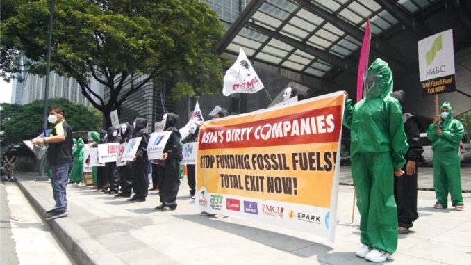
The Asian Clean Energy Forum (ACEF) 2021, a meeting of hundreds of civil society organizations and others interested in clean energy policy, was underway on June 15 in Manila, The Philippines, when one session came to a halt.
An Asian-led network of over 250 civil society organizations from around the world called NGO Forum on ADB decided to disengage from a session it was co-hosting alongside the Asian Development Bank (ADB). The session in question was about ADB’s draft energy policy. ADB is a multilateral bank that finances development projects, specifically involving fossil fuel energy across Asia.
“The focus of the ACEF discussions were topics like energy transition and of course these are important,” said Lidy Nacpil, coordinator of the Asian Peoples’ Movement on Debt and Development (APMDD), a member organization of the NGO Forum on ADB. “But we believe their approach to transition is not fast enough and not ambitious enough considering what we need to prevent climate catastrophe.”
In May 2020, the ADB released a draft of its energy policy. Titled “Energy Policy: Supporting Low Carbon Transition in Asia and the Pacific,” the document is a revision of the bank’s 2009 energy policy. The draft signals a shift away from coal financing, but it allows for financing of natural gas projects. And so, given a nod for continued financing of fossil fuel projects in an era of climate change, ADB’s energy policy has been criticized. Whether the bank will actually engage with such criticism though is another question.
“ADB has opened up consultations with civil society groups, but the meetings for these consultations are very brief,” Nacpil said. “There isn’t enough space for dialogue and debate about important passages in the energy draft, like the usage of false solutions like carbon capture and storage.”
Scientists have criticized technologies like carbon capture and storage for being “expensive, energy intensive, risky and unproven.”
The reasons for disengaging from the clean-energy forum included the lack of transparency, inclusivity and meaningful consultation with civil society in the ADB energy-policy review process. For many civil society organizations from across central, southern and southeast Asia, they did not experience anything but a one-sided push aimed at informing rather than engaging with participants.
NGO Forum on ADB added the ADB Sustainable Development and Climate Change Department (SDCC) has not provided any information about the timeline for consultations or the process by which inputs provided by groups like NGO forum on ADB will be taken into account before the draft is finalized.
This reporter sent questions to Bruno Carrasco, director general and chief compliance officer of the ADB SDCC regarding the lack of transparency and a need for Engagement, but received no comment.
Grassroots Voices Left Out
“The name ‘Asian Clean Energy Forum’ is a misnomer. ACEF is neither Asian nor clean,” said Vidya Dinker, national president of the Indian Social Action Forum (INSAF) and coordinator of Growthwatch, a research and advocacy group in India. INSAF is another member of NGO Forum on ADB. “It’s a networking event for ADB to reach out to people who they think will broaden their reach and business.”
In a press briefing held on June 18, Hasan Mehedi from the Coastal Livelihood and Environmental Action Network (CLEAN) Bangladesh, said, “ADB is continuing to finance fossil fuels including Liquified Fossil Gas and Waste to Energy while global scientific communities warn about any further investment for fossil fuels.” But Mehedi said ADB has yet to reach out to the project-affected communities on the ground. “Without consulting the affected communities and local civil society, how can ADB finalize such an important policy which has a direct impact on local communities and on the environment?”
Nacpil noted a need to “overhaul” ADB as an institution. The reasons, she explained, includes “neoliberal paradigm and strategies,” “undemocratic governance system” and the “use of loans as leverage to reshape Asian economies, according to its private sector and market driven growth framework.”
Filipino climate campaigners biked their way to @ADB_HQ in Manila to call on governments and financial institutions to end support for fossil fuels, and undertake urgent climate actions. This action comes in line w/ this year’s #ClimateWeekAP. #FossilFuelFreeAsia @UNFCCC https://t.co/p0ePeNPwTw pic.twitter.com/lEoyx1o5T0
— APMDD (@AsianPeoplesMvt) July 9, 2021
Demands for Loan Cancellation
In a statement submitted as part of the Fossil Free ADB campaign, APMDD said “financing of fossil fuel projects has largely been in the form of loans. In addition to the grave impacts and implications of its fossil fuel financing on people, communities and on the climate, we are also deeply concerned that ADB’s fossil fuel financing has also exacerbated the debt burdens of its member countries. It is only fitting that the ADB Energy Policy Review also address the loans involved in its fossil fuel financing.”
The @ADB_HQ pledges full alignment to the Paris Agreement goals by 2023 to 2025 but its energy policy draft’s still open to financing gas and other harmful projects.#GasIsNotATransitionFuel#StopFinancingFossilFuels#NoToFalseSolutions pic.twitter.com/DFVu6wbo6v
— APMDD (@AsianPeoplesMvt) July 12, 2021
The Fossil Free ADB campaign is aimed at ensuring a “no fossil fuels” ADB energy policy. It is organized by a group of civil society organizations, researchers and activists, including NGO Forum on ADB, Asian Peoples’ Movement on Debt and Development (APMDD), 350.org and the Consortium for Energy, Environment and Demilitarization.
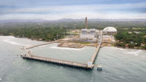
APMDD called on ADB to adopt a policy and take action that will address accountability for impacts of ADB-financed coal projects and ways to ease the debt burden created by ADB lending, especially lending to harmful projects.
“In their draft energy policy, they acknowledge coal projects have been problematic and that’s why we need to shift to clean energy now,” Nacpil explained. “But they are not taking into consideration the economic impacts of the projects they have funded, the kind of financial burden these projects have brought to countries.”
Rayyan Hassan, executive director of NGO Forum on ADB, said that with ADB’s coal ban having yet to be implemented, it is logical to consider calls for decommissioning old plants and the loans associated with them. Examples of such plants include the Masinloc and Visayas thermal power plants in The Philippines, the Tata Mundra coal plant in India, and Jamshoro coal plant in Pakistan.
In response to questions about debt relief, Dr. Yongping Zhai, chief of the energy sector group at ADB said that for ADB, “offering any form of debt relief to any of its borrowing member countries will compromise its preferred creditor status, which underpins ADB’s strong credit ratings. Our strong credit rating is critical for ADB to offer low-cost funding to all borrowing member countries, in support of their development efforts.”
“Yongping Zhai is speaking as a banker, not a development banker who is concerned about member countries’ debt burdens,” Dinker said.
As of now, the draft energy policy does not specify if any debt relief will be provided in relation to fossil fuel projects. It remains to be seen if this undergoes a change as deliberations with civil society groups and activists move ahead. The draft is up for submission to ADB’s board of directors later this year.
Rishika Pardikar is a freelance journalist in Bangalore, India.
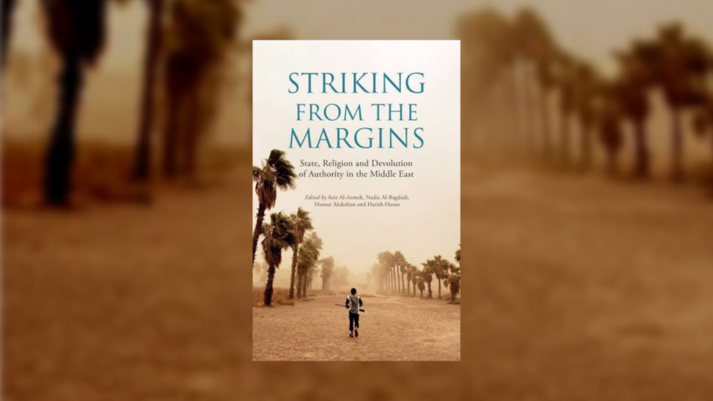
Book Review: ‘Striking from the Margins’ Avoids Trying to ‘Fix’ West Asia—or What Is Known As the ‘Middle East’
Editor’s Note: Toward Freedom uses “West Asia” to describe what is referred to as the “Middle East,” a term with colonial roots.
Striking from the Margins edited by Aziz Al-Azmeh, Nadia Al-Bagdadi, Harout Akdedian and Harith Hasan (London, United Kingdom: Saqi Books, 2021)
The tumultuous state of West Asia has been a contentious topic within many academic and social circles for centuries. Over the past half-century many academics, politicians and strategists have put forth initiatives, programs and policies focused on reconstructing the region.
For far too long, Western countries have seen West Asia as an underdeveloped expanse of land and resources controlled and governed through antiquated religious and social policies. What separates Striking from the Margins from other discourses on the region is its commitment to addressing the misconceptions that often keep people from understanding the relationship between West Asian countries and the Western ones that occupy and use their territory mostly for economic benefits.
The Disconnect Between East and West
One of the reasons such a disconnect exists between those living in West Asia and the Western countries, whose tax dollars finance the implementation of interventionist policies, is due to a lack of understanding regarding West Asian governance. While the United States’ two-party system is imperfect, it offers an often-predictable outcome that effectively reinforces the country’s status quo as a leading economic power across the globe. On the other hand, many countries in West Asia face a more challenging set of circumstances to develop their economies. For example, in the early 2000s Iraqi President Saddam Hussein’s government was not only dealing with warring Shi’i and Sunni factions seeking power within Iraq, but also Islamists and U.S. troops fighting to control the region. Research done by Greek political scientist Stathis Kalyvas shows a combination of sectarian conflict along with “a short war between U.S. troops and Shi’i militias” led to Iraq experiencing “a collapse of state capacity.” (pg. 37) Such a collapse has continued to make it difficult for the country to rebuild and develop. This book effectively outlines the circumstances that have kept certain West Asian countries from modernizing.
Striking from the Margins is not a dissertation that seeks to “fix” the region. Instead, the authors push for a reconceptualization along with reasonable policy changes that would be more economically beneficial to those regions. Understanding the type of social, religious and economic pressures West Asian countries face is pivotal to building stronger and more equitable partnerships between those countries and Western ones. In the book, two of the authors, Aziz Al-Azmeh and Nadia Al-Bagdadi, effectively highlight the hypocrisy of interventionism, along with its role in destabilizing West Asia. They offer a diligent overview of state formation in the region.
In writing that “the modern state in the Mashreq arose from the needs of internal reform arising in response to global, arguably colonial pressures from outside and from internal processes of modernization, starting with the Ottoman reforms of the 19th century” (pg. 8), the authors offer a concise historical context regarding state formation in the region. But when they go on to state that “the most artificial state” and yet the strongest in West Asia is Israel (pg. 8), the blatant contradiction between regional support and global impact becomes evident. On one hand, powerful states in the region historically gained their legitimacy through a combination of regional support, resource management and tribal warfare. However, the most powerful country in the region, Israel, is not supported by neighboring countries like Egypt, Syria and Lebanon. It instead maintains legitimacy through a “client state” relationship with the United States. Thus, Israel possesses an imbalanced stronghold over the region when it comes to warfare. When discussing West Asia and the constant demands for reform in the region, it is important to explore the role Israel and the United States have played in maintaining the economic status quo.
Religious Fundamentalism and Global Capitalism
In lieu of adequate research most people tend to assume that religious fundamentalism is the leading factor stifling the development of West Asian countries. However, research suggests economic inequalities are the leading cause of instability in the region. Kalyvas writes “$1,000 less in per capita income is associated with 41 percent greater annual odds of civil war onset, on average.” (pg. 30) The Gulf Cooperation Council consists of Bahrain, Kuwait, Oman, Qatar, Saudi Arabia and the United Arab Emirates. Together, they represent a regional, intergovernmental, political and economic union designed to integrate multiple economies and bolster infrastructure across member countries. The issue is such integration comes at a significant cost for the “migrant workers [who] have been fundamental to patterns of urban growth and capital accumulation in the Gulf.” (pg. 57) Hanieh explains “a large number of temporary migrant workers… from South Asia and, to a lesser degree, the Arab world… make up more than half of the Gulf’s total population of 56 million.” (pg. 57) Even though these workers account for more than 59 percent of the labor force within the Gulf, they have been denied labor, political and civil rights. Much of the political and economic capital used to support growth across the region is not helping the people who need it the most.
In closing, several competing entities influence the economic, social and political infrastructure of West Asia. The most important are the countries in the region, specifically those that make up the Gulf Cooperation Council, as well as non-member countries like the United States, who have a vested interest in the maintenance and development of certain programs and countries in the region. The value of Striking from the Margins is its subtle refusal to put forth a heavy-handed, neoliberal proposal on how to “reform” West Asia. Instead, it offers proper context for readers to take a step back, thoughtfully assess the situation and envision new ways to embark on such a difficult development process.
Timothy Harun is a writer and actor based in Los Angeles. He holds a B.A. in journalism from Hampton University.
