Don’t normalise Africans dying while attempting to cross the Mediterranean. Dozens of bodies have now washed up in Libya, a day after the same happened in Tunisia. pic.twitter.com/A83tv9wXQe
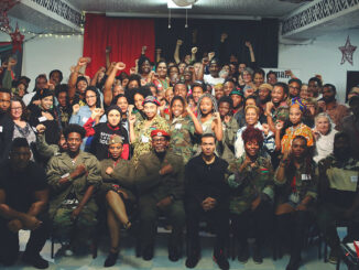
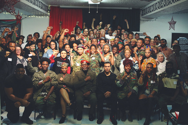
Attendees of the African People’s Socialist Party (APSP) Plenary 2017. In the front row includes recently indicted defendants Gazi Kodzo (first from left with fist on chest) and Omali Yeshitela (third from left with red beret) / credit: The Burning Spear
Activists on the left, as well as radical U.S.-based organizations, came out yesterday against the indictments of three members of the African People’s Socialist Party (APSP), one former party member, and three Russian nationals for allegedly attempting to sow discord in the United States by working with Russia.
The U.S. Department of Justice (DOJ) announced Tuesday, April 18, that a federal grand jury returned a “superseding indictment” charging the four people with:
…working on behalf of the Russian government and in conjunction with the Russian Federal Security Service (FSB) to conduct a multi-year foreign malign influence campaign in the United States. Among other conduct, the superseding indictment alleges that the Russian defendants recruited, funded and directed U.S. political groups to act as unregistered illegal agents of the Russian government and sow discord and spread pro-Russian propaganda; the indicted intelligence officers, in particular, participated in covertly funding and directing candidates for local office within the United States.
The four charged include:
Omali Yeshitela, a U.S. citizen residing in St. Petersburg, Florida, and St. Louis, Missouri, who serves as the chairman and founder of the APSP;
Penny Joanne Hess, a U.S. citizen residing in St. Petersburg, Florida, and St. Louis, Missouri, who is chairperson of the African People’s Solidarity Committee;
Jesse Nevel, a U.S. citizen residing in St. Petersburg, Florida, and St. Louis, Missouri, who is chair of the APSP’s Uhuru Solidarity Movement; and
Augustus C. Romain Jr., aka Gazi Kodzo, a U.S. citizen residing in St. Petersburg, Florida, and Atlanta, who once served as secretary-general of the APSP and is a founder of the Black Hammer Organization in Georgia.
Repressing Africans in Struggle
Hess and Nevel are white solidarity members. Nevertheless, that an African organization was targeted has raised concerns.
Anti-imperialist African organization Black Alliance for Peace yesterday issued a statement pointing to the U.S. government’s history of repressing the African liberation struggle:
Not since the Palmer Raids of the early 20th century, nor since the indictment of W.E.B DuBois in 1951, or the confiscation of Paul Robeson’s U.S. passport during the anti-communist “McCarthyist” era, has there been such a hysterical response to African people asserting their rights and freedom of speech in the United States. This renewed attack against anti-imperialist Africans, framed within the absurd notion of “Russian influence,” comes as capitalism decays and U.S. global hegemony loses its hold on the world. The attacks on the APSP and the Uhuru Movement are part of a historical tendency to align African political activists with U.S. “adversary” states to marginalize African internationalism (including solidarity with Cuba and Palestine, for example) and to suppress Black radicalism.
It is also an assault on the efforts of Africans organizing against the violence and murders suffered at the hands of the U.S. state. Indeed, Africans do not need Russia to tell them they are suffering the brunt of violence in the heart of the U.S. empire!
Wayne State University professor Dr. Charisse Burden-Stelly noted her forthcoming book, Black Scare/Red Scare, points to the APSP raid of July 2022 to draw the connection between U.S. domestic anti-communist purges of the past and repression of activists today.
“It is no coincidence that an African socialist organization is being targeted,” she tweeted.
US charges 4 Americans, 3 Russians in election discord case
I start the epilogue of Black Scare/Red Scare with this case to discuss the resonances of those scares today. It is no coincidence that an African socialist organization is being targeted. https://t.co/SnVgP94m3N
The DOJ attempted to connect the charged activists with a Russian conspiracy to interfere in U.S. elections, beginning with the 2016 election of Trump.
“Russia’s foreign intelligence service allegedly weaponized our First Amendment rights—freedoms Russia denies its own citizens—to divide Americans and interfere in elections in the United States,” said Assistant Attorney General Matthew G. Olsen of the DOJ’s National Security Division.
However, much evidence exists to show the United States interferes the most in other countries’ elections and democratic processes. Aside from invading 201 countries since the end of World War II, the United States deployed 64 covert operations to subvert governments around the world between 1947 and 1989, according to political scientist Lindsey O’Rourke. Meanwhile, political scientist Dov Levin’s work found the United States interfered in 81 elections between 1946 and 2000.
Attacking Activists
The APSP had been preparing for this moment since late December, when they received “strong indications” of indictments coming down in early 2023 after the FBI had raided the party’s properties in July 2022, as Toward Freedom had reported. Then the APSP announced last month that Regions Bank, a financial institution in the U.S. South, had closed the party’s accounts and withdrawn lines of credit. The APSP referred to that move as “U.S. economic sanctions” on Black community projects.
Freedom Road Socialist Organization also issued a statement that referred to more recent history of repression.
On September 24, 2010, the FBI raided seven homes of anti-war activists and the office of the Twin Cities Anti-War committee. All told, twenty-three activists were subpoenaed to a Chicago-based grand jury that claimed to be investigating “material support for terrorism.” As time went on, the FBI continued their attack on anti-war and international solidarity activists by targeting important veterans of the movement who worked with the Anti-war 23, including Chicano activist Carlos Montes in Los Angeles and Palestinian organizer Rasmea Odeh in Chicago. A national defense campaign defeated most of these attacks.
Toward Freedom Board Secretary and independent journalist Jacqueline Luqman commented on the danger for all activists who oppose U.S. global hegemony.
“Today it’s the APSP. Tomorrow it could be you and me,” she tweeted. “All you need to do is oppose US imperialist policy in Ukraine and Palmer Raids 2023 will be unleashed to silence you.”
Today it's the APSP. Tomorrow it could be you and me. All you need to do is oppose US imperialist policy in Ukraine and the Palmer Raids 2023 will be unleashed to silence you. #NoCompromiseNoRetreathttps://t.co/E9qb3pQz1F
Editor’s Note: This article was originally published by Kawsachun News.
Comrade Chris Matlhako, the Secretary for International Affairs of the South African Communist Party and Central Committee member, passed away in the morning of April 20, 2023, at the age of 58. He was a diligent friend to the peoples of Latin America and the Caribbean and partner in the building of socialism internationally. Deepest condolences were expressed by the Cuban embassy and Ambassador in South Africa: “The world loses one of its most exceptional sons.”
Chris, an internationalist, traveled on many occasions to Venezuela and Cuba, offering solidarity and accompaniment from Africa and was an important voice in opposing NATO and the cold war on China. Chris condemned imperialist aggression against Palestine, Cuba, Venezuela, Iran and other countries, urging international solidarity from South Africa and was on the Steering Committee for the Black Alliance for Peace’s U.S. Out of Africa Network.
The African National Congress paid tribute in a statement that can be read here.
Below is the statement issued by the South African Communist Party on Comrade Chris Matlhako’s passing.
South African Communist Party
20 April 2023
SACP dips its red flag and mourns the passing of Central Committee member Comrade Chris Matlhako (21 October 1964 – 20 April 2023)
The South African Communist Party (SACP) conveys its message of deepest condolences to the family of Comrade Chris Matlhako, SACP 15th National Congress Central Committee member who served our Party and movement diligently.
Comrade Chris Matlhako passed away on Thursday morning, 20 April 2023.
The SACP also sends its message of condolences to the entire liberation movement which he served till he breathed his last, as well as the working-class across the world.
At the time of his passing, Comrade Chris Matlhako served the SACP as a full-time Central Committee Member as elected by the SACP 15th National Congress held 13 – 16 July 2022. In this capacity, he served as Secretary for International Relations at the Party’s Headquarters in Johannesburg. Previously, he was the SACP 2nd Deputy General Secretary as elected by the 14th National Congress in 2017, and served as a Central Committee member before that tenure. He was also a member of the African National Congress and participated in the mass democratic movement as an activist and leader.
Comrade Chris Matlhako joined the South Africa liberation struggle as a student, actively participating in the student movement to fight against the apartheid system. He later joined the SACP and never shifted from the socialist course.
An astute intellectual fully committed to the socialist cause, Comrade Chris penned many articles for various publications, local and international, on numerous subjects concerning the revolution. A collection of his articles published in various publications over the years was made available and serialised in the magazine Thinking Che, with the first volume appearing in 2019.
Comrade Chris Matlhako did not limit himself to serving the South African working-class, however. He also spread himself across the world, helping to raise the international struggle against imperialism and assiduously delivering the SACP’s message to various parts of the world. As part of his internationalist work, Comrade Chris served as the General-Secretary of the Friends of Cuba Society – South Africa (FOCUS-SA) and was also a member of the South African Peace Initiative, among other responsibilities. He also represented the Party in the Working Group of the International Communist and Workers Parties, directly contributing to shaping and sharpening the socialist voices across all lands.
In paying tribute to Comrade Chris Matlhako, the SACP will continue to tirelessly organise the working-class, galvanise the left forces in order to deepen the building of a socialist movement of the workers and the poor, as mandated by our 15th National Congress. In taking forward his work, the SACP calls for more revolutionaries to actively involve themselves in Marxist-Leninist intellectual work as well as working-class internationalism.
The SACP calls upon young communists, as led by the Young Communist League of South Africa, whom Comrade Chris worked very hard to nurture, to preserve his legacy by organising the youth of our country to fight against imperialism, towards socialism.
Editor’s Note: This article was originally published by Peoples Dispatch.
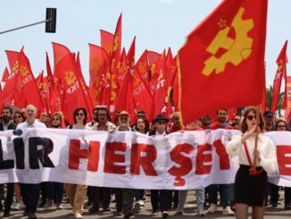
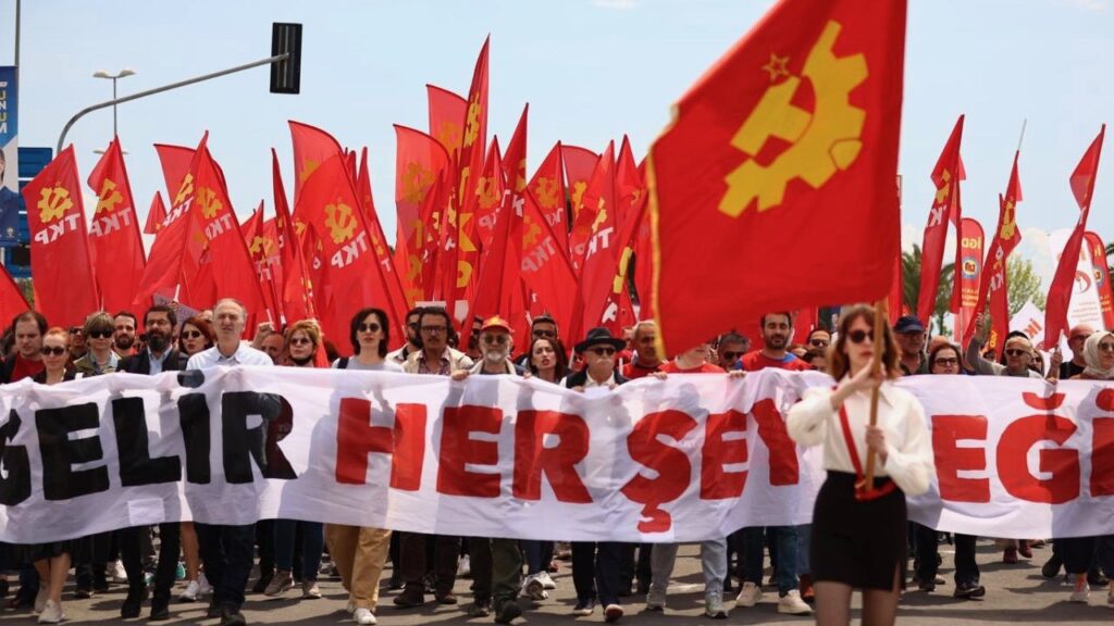
International Workers’ Day celebrations were held in different countries of the West Asia and North Africa region on Monday, May 1, with trade unions and left parties organizing mass demonstrations. Marking the day, workers raised slogans of unity and revolution against capitalist exploitation.
Paying homage to the martyrs of Chicago, Tunisia’s largest trade union movement, the Tunisian General Labour Union (UGTT), issued a statement on behalf of its general secretary Noureddine Al-Tabouni. It said that the UGTT was founded “on the principles of labour solidarity and victory of the interests of the workers and general public in all parts of the world regardless of race, gender, color and belief.”
The statement asserted that successive governments in Tunisia, including the current one, have been following a neoliberal economic regime, which has caused massive suffering to the working class. It also noted that the trade union movement in Tunisia is currently under attack from an “authoritarian government which tries to demonize everyone who disagrees with it.” The union called on its members to show greater resolve in the values of the workers’ movement, and asked for greater support and solidarity from movements across the world.
The UGTT added that the Kais Saied government, following the neoliberal model, is now trying hard to compromise with the IMF and refuses to raise wages in the country, instead choosing to attack the working class movement. The UGTT pledged to fight against the neoliberal and corrupt policies of the present government.
In a similar statement, the Workers’ Democratic Way Party of Morocco saluted the spirit of May Day and noted that the working class needs to realize a dignified life first and foremost. It said that the occasion provides an opportunity to revisit the challenges facing working class movements and renew pledges to overcome them. Highlighting the need for a militant and united trade union movement in the country as the first step to achieve dignified and democratic conditions for workers, it resolved to “put an end to all divisions and differences” present in the working class in the country today.
Commemorating May Day, demonstrations and rallies were also held in countries such as in Lebanon, Turkey, and Iraq—where a large march was taken out in capital Baghdad.